• Don't miss out on all the fun! Register on our forums to post and have added features! Membership levels include a FREE membership tier.

Togwotee snow?

christopher

Well-known member
Staff member
Lifetime Membership
Nov 1, 2008
81,519
27,382
113
Rigby, Idaho
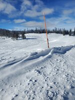
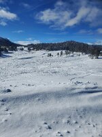
Togwotee pass this morning 11/27/2023.
About 12". people are riding.!!! Looks like all the snow is east of the Continental divide in Fremont county Wy.
At least for now.
that is just SO BARREN!
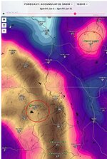
Lord I hope the snow comes SOON.
We are off to a Misérable start.
 

christopher

Well-known member
Staff member
Lifetime Membership
Nov 1, 2008
81,519
27,382
113
Rigby, Idaho

GENERAL AVALANCHE INFORMATION​

TOGWOTEE PASS​

Print

ISSUED​

Friday, December 1, 2023 - 9:49AM

EXPIRES​

Sunday, December 3, 2023 - 8:00AM

AUTHOR​

Travis Baldwin
0.png

THE BOTTOM LINE

Our weak snowpack is about to be stressed with a significant snow load at mid and upper elevations. Evaluate the snowpack carefully and use conservative decision-making this weekend with the incoming storm. Pay attention to the snowpack and watch for shooting cracks, whumphing and active wind-loading above 8000 feet. These are all signs of an unstable snowpack. Be mindful of what is above you and remember that slopes can be triggered from below. The consequences of getting caught with a thin snowpack can be traumatic.

Daily zone forecasts with danger ratings will begin this weekend when there is adequate snow cover.
 

christopher

Well-known member
Staff member
Lifetime Membership
Nov 1, 2008
81,519
27,382
113
Rigby, Idaho

FORECAST DISCUSSION​


We have several considerations moving into the weekend including the weak existing snowpack, an incoming storm and the avalanche problems that will develop.

The Set-up:
The last week of clear and cold weather has driven facet development in early season snow on shady aspects at mid and upper elevations. As a result, we have a weak underlying snowpack. This observation shows a typical scene of what could be below the surface. Be wary of thin spots, particularly above 8000’ on NW-N-NE-E aspects in steep, rocky terrain, where you are more likely to trigger an avalanche.

In addition, last week’s strong wind event created thick, stiff wind slabs. Winds were out of the east and slab formation was unusual in size and distribution. These slabs are generally firm and can be triggered from anywhere on the slope. The consequences of getting caught by one of these stubborn, older wind slabs could be severe given the many obstacles peppering avalanche paths. This observation and this one are great examples of this problem encountered last week.
What’s Next:

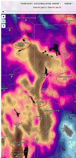
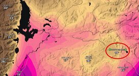
Forecasts are calling for a significant amount of moisture with the storm this weekend, starting today (Friday). Several inches have already accumulated at mid-elevations in the Tetons since midnight. Up to 30" of new snow consisting of over 2.5” of water, could fall in the upper elevations. A lot of weight is about to be added to the existing snowpack. West and southwest winds will start to ramp up this evening (Friday) and continue to climb on Saturday, possibly gusting above 40mph, particularly above 8,000’ in the Tetons. Slabs will build on leeward (N-NE-E) terrain in the alpine and any mid-elevation terrain getting cross loaded.
Shifting our focus to future snowpack issues, monitor how the new snow is bonding to the old snow. Look for evidence of wind loading around ridgetops on all aspects as well as mid-elevation terrain exposed to the wind. Pillows, thicker drifts, whumphing and cracking are signs of this problem and poor stability. Below 8000’ in most zones, and on sunny slopes, the snowpack is very thin to nonexistent. This means that whatever snow falls this weekend is the only snow covering rocks, stumps, and trees. Continue to travel cautiously if you choose to go into the mountains.

This weekend and through early next week, maintain extra margin for error knowing that the increased snow load and wind will increase the avalanche hazard. Select conservative terrain, use good travel techniques and cautious route-finding to reduce exposure to the avalanche hazard. It’s going to take a lot more snow to bury obstacles and early season problems. Be patient as this happens.


MI1M600EFI

Well-known member
Lifetime Membership
Premium Member
Nov 15, 2008
298
117
43
50
Mancos, CO
We have a trip to the area planned between Xmas and NY... Looks like the snow level is a bit behind last year at this time, and the 10 day forecast shows nothing whereas last year it started snowing about now all the way through New Years... Might have to reconsider this trip, or bump it into late Jan or early Feb. That would let us visit the military vehicle museum too, which would be a bonus.

So far, I'm pretty disappointed with the "Super El Nino" that we are supposedly in...
 

Wintertime

Well-known member
Lifetime Membership
Apr 18, 2014
380
177
43
Casper, WY
With the current conditions up there I wouldn't travel far to ride there. The trails are groomed nice and you could break a sled in. Lots of stuff hidden in the snow. The snow will show up it always does just a little slow this year.
 

MI1M600EFI

Well-known member
Lifetime Membership
Premium Member
Nov 15, 2008
298
117
43
50
Mancos, CO
Man, snowfall this year is not off to a good start anywhere... Last year we were there between Christmas and New Years and Tog went from 40" to 47". This year it's presently at 26", with only a little snow forecast for the next 10 days... I've been doing my snow dance twice a day, are the rest of you slacking??? :)

We'll be out there Jan 22-26... Hoping there's at least as much by then as there was at this time last year...
 

1962Cat

Member
Lifetime Membership
Premium Member
Jan 10, 2021
16
20
3
Moran WY
I have been slacking. My co workers have been up there riding, with the expected outcome.
Bent and broken control arms.
What snow there is is hard, and you have to beat your sled up to get to any powder.
We have had plenty of cold weather. Its below 0 every morning, very little melting
 

IDspud

Well-known member
Lifetime Membership
Premium Member
Nov 26, 2007
2,604
3,974
113
Oakley, ID
Christopher’s forecast is like viagra for bald guys.
Gets your hopes up, but leaves you hanging.
 
Premium Features