M
MtnDoo
Well-known member
1/4/09 Update
1/4/09 Update
Happy New Year SW'ers!!
We've received about 10-14" of fresh snow over the past three days up high. This new fallen snow sits on top of a 1" layer "quarter" sized surface hoar. This will almost certainly create yet another near surface weak layer as more snow arrives; hopefully it consolidates. Riding on the surface hoar a few days ago it sounded like riding over sand or small gravel.
It was partly sunny/cloudy today with high clouds and fog today, but patches of sun. Daytime temps were in the 20's.
Grooming: Turbo is working on getting Ohio Pass road open and is about 1/3 of the way through from the summit. Greg went out today and groomed Kebler Pass from CB Trailhead to the "Y", went up into the rolling hills, tilled Old Kebler Pass road. Tomorrow we'll put the drag on the cat and drop the tiller - hopefully this will allow us to knock down some more of the rollers on Kebler Pass.
MtnRooster - the area that people were climbing in (in earlier report) was directly below a large wind ridge, and through an area that gets little sun until late in the day which creates soft spots in the snow pack (trigger points). I'd steer clear until it sheds. If it goes, it will release all the way to the ground to the november layers.
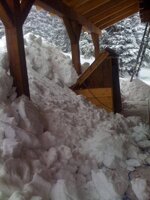
As a side note: Roof shoveling sucks. (grin) Shovel early, shovel often, or hire it out. Nearly 200" of snowfall in December was too long to wait. I finally got 50"+ of hardened layers cleared and created a 12 foot tall pile of slabs in front of our house. A few pics attached.
MtnDoo
**********************1/4/09 CB Avalanche Center Info***************
Weather Synopsis
As the storm cleared out last night temperatures plumeted while leaving us with up to a foot of new snow through the Elk mountains. Today a moist Southwest flow pushing through the four corners region will deliver snow to the San Juan Mountains. This will likely be too far south to bring us any snow, though possibly a few snow showers and cloudy skies. By Monday a strong Northwest flow dips in from the Pacific Northest carrying a fair bit of moisture. Watch for snow to begin Monday afternoon and deliver a good punch on Monday night and Tuesday morning fueled by a strong jet stream and cold air.
In the Backcountry
We received up to a foot of new snow yesterday which was light low density snow. There were some winds yesterday but most transport was limited to high elevations above tree line. This new snow burried a significant layer of large Surface Hoar Crystals that was pretty widespread before yesterday's storm. Observers already reporting the presence and some failure on the burried Surface Hoar Layer. This layer will become a persistent weak layer that will need to be closely monitored as it gets burried deeper in the snow pack, especially with more snow in the forecast for early this week. For now wind slabs from yesterdays snow will be limited to near and above tree line on exposed ridge tops and terrain features. We are mostly seeing an improving snowpack with facets near the ground slowly rounding and a hard and supportive mid-pack. This is promising and can lead one to start having some confidence in our snow pack. The scary part is deep slab instability still exists. Though most areas of the snow pack seems deep, consolidated and homogeneous there are still areas that are shallow and weak where the ground facets are persisting and the weight of a skier or snowmobiler can easily collapse the slab. If a failure initiates it could still propagate wide and run deep (see photos) and produce a large avalanche.
Concerns
It is time to start monitoring the layer of buried surface hoar and watch for slabs building on top of it. Currently wind slabs could be developed at high elevations below ridge tops and wind exposed terrain features. With wind today and some settling of the new snow, slabs will continue to develop today.
Deep slab instability still exists! There is a deep hard slab in the snow pack and persistent facets on the ground. Deep Slab avalanches are becoming harder to trigger but the size and destructive potential will be large if triggered.
Back country travelers need to stay on their toes today . Watch for areas of wind hardened snow and be aware of where the lee slopes are. Lee aspects can have a fair bit of snow and can be easily triggered especially if sitting on the burried surface hoar. Watch for cracking as this is a sign of developing windslabs. If you choose to dig a pit or profile maybe think about targetting a shallow area. On any slopes steeper than 30 degrees identify starting zones and trigger points and avoid these areas. Shallow areas in the snowpack, rock band, and small tree islands should be avoided especially in steep starting zones, as these are the most likely area to trigger deep slab avalanches.


Last edited:


