• Don't miss out on all the fun! Register on our forums to post and have added features! Membership levels include a FREE membership tier.

Bearclaw Bob's 2

Thread Rating
5.00 star(s)

bearclawbob

Well-known member
Lifetime Membership
Nov 27, 2007
1,525
1,095
113
Good morning from Bearclaw and Super 8. Woke up to 2 inches of powder in town and I went up on the mountain this morning to rescue a sled that had broke the steering post. I found any where from 2 inches up to 6 inches of fresh powder. I thought I'd find it hard to stop going down hill and it wasn't bad. It was hard to see, light was flat. The snowman is calling for a trace today and dropping down to the teens and warming up tomorrow to the mid 20's with sun. The rest of the week looks about the same.

AVALANCHE CONDITIONS:

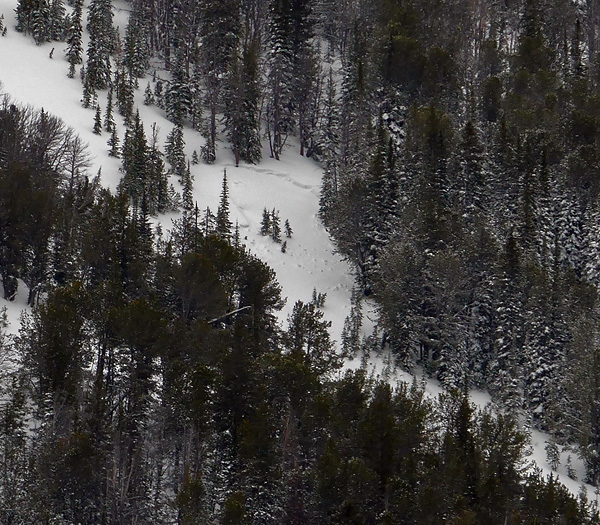
For what it's worth, this fresh coat will help general riding conditions without rapidly increasing the avalanche danger. On most slopes, facets near the ground have gained strength and should be able to handle this recent load. But, as demonstrated by a recent avalanche in Cooke City (photo), some slopes have a structure willing and able to produce avalanches (video, video).

Slopes that have received a recent wind load will be the most suspect. Although winds have not been overly strong, fresh wind slabs will likely exist on upper elevation slopes leeward to west winds. These slabs will be relatively small in size, but could carry a skier or rider into unfriendly terrain. Fresh wind-blown snow will also add stress to weak facets near the ground. Avoiding steep, rocky, upper elevation terrain will be the best way to avoid triggering a slide on this layer.

Today, the excitement will be high and skiers and riders will be eager to push it in avalanche terrain. Although this storm wasn’t huge, it was big enough to notch up the avalanche danger. Now is no time to let your guard down. Pay close attention to your surroundings and always be thinking about the consequences of an avalanche.

Today, human triggered avalanches are possible and the avalanche danger is rated MODERATE. If snow and wind continue through the morning hours, the avalanche danger could rise to CONSIDERABLE on steep, wind loaded slopes.

I've started a face book account, check it out.
Just to let guys know that I do let people work on their sleds in the garage, store your sleds at night. I carry a large selection of snowmobile parts. I do work on sleds and I have over 25 years of experience. I was a Arctic dealer at one time.
I sell all types of AVALANCHE EQUIPMENT AND ALSO RENT. We also fill tanks.

If you brake down and need a sled, check out my prices for rentals.
The bakery is offering a PRIME RIB dinner, call for reservations.
 

bearclawbob

Well-known member
Lifetime Membership
Nov 27, 2007
1,525
1,095
113
cloudy

--------------------------------------------------------------------------------

Good morning from Cooke City. The snowman has changed his mind again. We are standing with a 20% chance of snow till Sunday and then it raises to 60% on Monday. Temp's are going to be in the mid 20's with lows in the mid teens.

AVALANCHE CONDITIONS: Lionhead area near West Yellowstone Cooke City

The mountains from Big Sky to West Yellowstone and Cooke City failed to get a full serving of new snow over the weekend and had to settle for a taste of just a few inches. The main concern in these areas is sugary facets on the ground which is the weakest layer in the snowpack. On many slopes these crystals are getting stronger and bonding as stability test scores climb upward and in many cases fail to propagate fractures. Although there is an upward stability trend, a few slopes are still misbehaving. One party of skiers in the Beehive Basin area found facets breaking at the ground while another group got clean fractures on a stout ice crust under the new snow. Digging a quick stability test gave them all the information they needed to back off.

It is not “Green Light” conditions in the backcountry since lingering instabilities will keep us on our toes. For today, the avalanche danger is rated MODERATE on all slopes.

Don't forget to make reservations for the PRIME RIB at the Bakery for NEW YEARS EVE. You can take a chance and come in that morning and get on the list.
 

bearclawbob

Well-known member
Lifetime Membership
Nov 27, 2007
1,525
1,095
113
lightly snowing

Good morning from Cooke city. The snowman hasn't changed his mind, but we picked up another 2 inches over night. It's lightly snowing and over cast. The weekend is still showing a 50% chance of snow.

AVALANCHE CONDITIONS:
The snow that just fell is 5-7% density powder which will greatly improve the skiing and riding without adding a lot of weight to stress the weak layers. I toured up Mt. Blackmore in Hyalite yesterday while Mark was riding around Cooke City. We both found that the weak facets at the ground are still a problem in isolated locations, but they are not breaking in our stability tests. Although the snow structure is similar in our advisory area, the snow depth and rate of strengthening is uneven.

Snowfall since this weekend fell onto a variety of surfaces, not all of them good. Some slopes were blanketed with small-grained facets or feathery surface hoar before the new snow fell making the new/old snow interface the most unstable part of the snowpack (video).

For today natural avalanche activity will be rare, and other signs of instability (collapsing and cracking) will only be sporadic, but the snowpack still demands a bit of investigation. Weak facets at the ground or under the new snow are the problem, especially if they are under a wind slab (video, photo). For today the avalanche danger is rated MODERATE throughout southwest Montana since it is still possible to trigger slides. Be wary of wind-loaded slopes near the ridgelines where thin soft slabs may have formed.

The bakery was busy yesterday with the best seller again was a tie between the French toast and the breakfast burrito.
The PRIME RIB dinner is starting to fill, we still have lots of room for reservations. You can pick a time between 5 pm and 7:30pm when you would like to have dinner.
 

bearclawbob

Well-known member
Lifetime Membership
Nov 27, 2007
1,525
1,095
113
light snow and windy

Good morning from Cooke city. We are in a winter storm warn till noon Monday. The snowman is calling for 5 inches tonight and another 8 inches by tomorrow with strong winds each day.
Don't forget a present to your girl friend or wife. This will help you come out and ride here in Cooke.

Yes all the trails are being groomed.

AVALANCHE CONDITIONS: Today, the primary avalanche concern will be wind slabs. New snow combined with winds out of the west and southwest will produce fresh slabs below ridgelines and on the leeward side of cross loaded terrain features. These newborn wind slabs will be sensitive to human triggers and have the potential to propagate farther than one might expect. On Wednesday, skiers triggered many small wind slabs near Fairy Lake in the Bridger Range (photo). This is a good example of what will be possible around our forecast area today. Avoiding slopes with wind deposited snow will be the best way to avoid triggering a slide.

As snow slowly piles up, slopes will not need to be wind loaded in order to produce avalanches. Yesterday, skiers north of Bridger Bowl triggered a few small slides that failed on a layer of facets that formed during the mid-December dry spell. This layer can be found throughout our forecast area and will become increasingly active as it gets loaded by new snow (video). This layer exists less than a foot below the surface and is easy to assess by digging a quick snowpit. With more snow and wind in the forecast, I expect avalanches failing on this layer to grow in size and distribution.

A forecast wouldn’t be complete without talking about facets near the ground. While this pesky weak layer has gained strength in many areas, it continues to be a problem in others. Yesterday, Mark went to Beehive Basin near Big Sky and found this layer on many slopes (snow pit). It wasn’t an immediate problem due to the lack of a heavy load, but will certainly be a growing concern once we get more snow. Mark also found this layer in Cooke City earlier in the week. He felt it has gained strength on most slopes in this area, but continues to be an issue in steep, rocky terrain with a thinner snowpack (video).

Today, human triggered avalanches are likely on wind loaded slopes which have a CONSIDERABLE avalanche danger. Non-wind loaded slopes have a MODERATE avalanche danger.

Catch me on Face book, I'm running great buys each week on items.

The bakery's #1 seller for the second day running is the French toast.
 

bearclawbob

Well-known member
Lifetime Membership
Nov 27, 2007
1,525
1,095
113
More snow

Good morning from Cooke city. The snowman gave us about 7 inches by this morning and after I got done plowing, we had another 3. The snowman is calling for another 7 inches today and 2 more tonight. The winds should pick up.

AVALANCHE CONDITIONS: This latest storm has put the three day total at Fisher Creek Snotel site near Cooke City at 1” of SWE or close to a foot of new snow. The three day total for the mountains near West Yellowstone is around .8 inches of SWE. This is a heavy load for the snowpack to bear.

Today, the avalanche dragon will be lurking. Weak layers near the ground and closer to the surface, 8-12 inches deep, will be feeling the stress of the recent storm snow. Yesterday, Mark rode in the Taylor Fork in the southern Madison Range and found a well-developed layer of surface hoar about ten inches below the surface (photo, video). He also found plenty of weak snow near the ground. Doug found a similar set up on Mt. Blackmore earlier in the week (video).

In addition to the new snow, strong winds will be transporting snow onto leeward slopes, putting additional stress on these buried weak layers. Today, as snow and wind continue, I expect instability to rapidly increase.

For this reason, natural and human triggered avalanches are likely on wind loaded slopes which have a HIGH avalanche danger. Non-wind loaded slopes have a CONSIDERABLE avalanche danger.

Don't forget to follow me on Face Book.
 
R

Rev Kev

Well-known member
Nov 27, 2007
377
145
43
Lapeer Michigan
Latest From Cooke City
From the GNFAC,
Cooke City

The mountains near Cooke City received about 6 inches of new snow overnight. In the last 7 days this area has received 3 inches of snow water equivalent (roughly 3.5 feet of snow). Even though the snowpack is generally stronger than it is in other parts of the advisory area, this is a massive load for the snowpack to support. Wind loaded slopes may easily have double this load. Anything breaks when stressed enough, and the snowpack near Cooke City is no exception (photo). For this reason today, some avalanches may happen on their own, but a skier or snowmobiler will definitely trigger an avalanche if they enter avalanche terrain and the danger is rated HIGH on wind loaded slopes steeper than 35 degrees. All other slopes have a CONSIDERABLE avalanche danger.
 

bearclawbob

Well-known member
Lifetime Membership
Nov 27, 2007
1,525
1,095
113
Still snowing

Good morning from Cooke city. Yes I had a good Christmas, I hope ever one else did. The snowman is still giving us snow. Its about 2 inches a day. For tonight and tomorrow the snowman is calling for about 3 inches. Its going North of us this time, while Red Lodge is going to get about 7 inches from this next storm.

AVALANCHE CONDITIONS: The mountains near Cooke City contain a much deeper and stronger snowpack than other areas. Over the past few days I found remnants of weak layers in the snowpack, but these layers wouldn’t break in my stability tests (photo, video). Today, the main problem will be wind loaded slopes. New snow and moderate winds out of the W-NW have formed fresh wind slabs, which will likely fail under the weight of skier or rider. Additionally a few steep rocky slopes, like ones on Crown Butte or similar terrain, have a thinner snowpack where you could trigger an avalanche on a faceted layer near the ground. For today the avalanche danger is rated CONSIDERABLE on wind loaded slopes. Non-wind loaded slopes have a MODERATE avalanche danger.

The Bakery still has room for PRIME RIB on New Years EVE. Call for your reservations.

If you need a rental sled, come by and check out what I have to offer.
With over 25 years of knowledge working on sled, I offer my experience to any one needing help.
 

bearclawbob

Well-known member
Lifetime Membership
Nov 27, 2007
1,525
1,095
113
Sunny

Good afternoon from Cooke city. The snowman was hard on us last night. We woke up to 26 below. The temps are heading toward Zero and they will return to below Zero tonight.
If you want to find untracked areas, you must play in the trees. But you can still find covered rocks.

AVALANCHE CONDITIONS: In the last five days Cooke City received over an inch of SWE. Eric visited the area on Friday and Saturday and found a deep, strong snowpack with improving stability. Winds since then have loaded a few slopes that avalanched a foot deep in the new snow.

Lots of fresh snow, east winds and a buried weak layer are causing enough instability to warrant a CONSIDERABLE avalanche danger on wind-loaded terrain. On slopes without a wind-load the snowpack has a MODERATE danger since it is still possible to trigger avalanches.

The Bakery still has room for the PRIME RIB DINNER New Years Eve. Call or stop in tomorrow to get a reservation.

Stop by on face book and say HI. Would like to add you as a friend.
 

bearclawbob

Well-known member
Lifetime Membership
Nov 27, 2007
1,525
1,095
113
Sunny on NEW YEARS EVE

Good evening from Cooke city. The snowman was right again today. We woke up to 23 below and warmed up to 10 above. The forecast is warmer tomorrow with a high of upper 20's. The low will be 5 below. As the weekend draws near, we will see a 50% chance of snow Sunday and Monday.

AVALANCHE CONDITIONS: The weak layer I’m concerned with is two feet under the surface. The crystals are either a layer of feathery surface hoar or a thin layer of sugary facets. If you dig, either is seen as a stripe in the snowpit wall. The recent storms have not produced avalanches on this layer but our stability tests are still propagating fractures, a sign that skiers or riders could trigger a slope. Overall we are pleased with the trend toward stability which Eric expressed as “cautiously optimistic”

For today the avalanche danger is rated CONSIDERABLE on any wind-loaded slope and MODERATE on all other terrain.

The Prime rib dinner is going well, big turn out.

Be good tonight and stay out of Jail. :help:
 

bearclawbob

Well-known member
Lifetime Membership
Nov 27, 2007
1,525
1,095
113
HAPPY NEW YEAR

Good morning from Cooke city. The snowman is telling us that the temps are going to be in the mid 20's for the next few days and the lows will be above zero. :sun: Looks like we might see snow Sunday and Monday.

Hope every one has a good New Years.

AVALANCHE CONDITION: Persistent weak layers about 2 feet deep can produce an avalanche that will break over a much larger area than a wind slab. In some places like Cooke City these layers have gained significant strength. These layers seem to be gaining strength in the Bridger Range as well but I wouldn’t discount them just yet. In the mountains south of Bozeman to West Yellowstone (the Gallatin and Madison Ranges) these layers persist on many slopes and remain a very real avalanche problem. If you’re willing to pull out your shovel to look for an assess these weak layers, you can find slopes or areas where they either don’t exist or have gained strength as Doug found yesterday in the far southern Madison Range near West Yellowstone.

For today the avalanche danger is CONSIDERABLE on wind loaded slopes where fresh wind slabs can easily be triggered. With weak layers lurking in the snowpack in other areas, a MODERATE danger exists on non-wind loaded slopes.

If your looking to fill AVY bottles, we do it right here. This includes Snow Pulse, BCA and a exchange program for ABS.
We rent snowmobiles and AVALANCHE EQUIPMENT.

You can rent a space to work or store your sleds at night. Stop in and I'll show you what I have to offer.

The prime rib was a big hit, sorry you missed it.

WE WISH YOU ALL A HAPPY NEW YEAR :face-icon-small-hap
 

bearclawbob

Well-known member
Lifetime Membership
Nov 27, 2007
1,525
1,095
113
over cast

Good after noon from Cooke city. The snowman is calling for about an inch tonight and 2 inches tomorrow. We do have a chance of snow till Tuesday.
The temps are going to be in the mid 20's, with lows in the single digits.

AVALANCHE CONDITIONS: Some winds slabs will remain sensitive today and some slopes will harbor weak facets that may produce an avalanche. It’s worth taking 5 minutes and performing one quick test to double check stability. For today the avalanche danger is rated MODERATE.

I had a good friend ( Rowdy) make a avalanche sign showing different conditions. Check it out in front of the Bearclaw.
 

bearclawbob

Well-known member
Lifetime Membership
Nov 27, 2007
1,525
1,095
113
SNOW

Good morning from Cooke City. The snowman was right, we picked up 3 inches over night and we are looking at 2 more tonight and another 4 tomorrow. The temp's by Monday will reach the mid 30's.

Guys, when starting your sled in sub zero weather, make sure you either have your E- Brake on or bump your throttle several times to make sure its not froze. We had a accident yesterday. I had a good friend get run over by a snowmobile ( not a reindeer) He was lucky, he took a 3.5 hour ride down to Livingston to the hospital. He was OK, but will be really sore the next week or so. Please be careful.

AVALANCHE CONDITIONS: Cooke City

The mountains near Cooke City generally have a deep and stable snowpack. The main problem today will be wind slabs. A few inches of new snow combined with light to moderate W-NW winds will create small pockets of wind drifted snow in upper elevation, leeward terrain. This problem should be easy to recognize and avoid.

Today the avalanche danger on slopes steeper than 35 degrees is rated MODERATE. Less steep slopes have a LOW danger. If snow and wind continue through the day, the avalanche danger could bump up to CONSIDERABLE on steep, wind loaded slopes.

Need your Avy bottle filled, we can do it. We also carry every thing you might need in the line of avalanche gear.

HELMETS: We have a blow out special this year at $90.00.
 

bearclawbob

Well-known member
Lifetime Membership
Nov 27, 2007
1,525
1,095
113
MORE SNOW

Good after noon from Cooke city. The snowman changed his mind. We are in a WINTER STORM WARNING from 6pm tonight till 6 am Wednesday. We have over 10 inches of fresh powder on the mountain. We will see another 2 inches to day, 6 inches tonight and another 9 inches by tomorrow night. Going to have blowing winds in the afternoon on Monday.

AVALANCHE CONDITIONS: Yesterday, a snowmobiler triggered a wind slab near Lulu Pass outside of Cooke City. The slide was relatively small and the rider was able to avoid being caught. With more snow and wind in the forecast, wind slabs have the potential to grow in size and distribution throughout the day. Wind deposited snow may be resting over a layer of surface hoar which will make any wind loaded slope especially sensitive to human triggers.

Today, human triggered avalanches are likely on wind loaded slopes which have a CONSIDERABLE avalanche danger. Non-wind loaded slopes have a MODERATE avalanche danger. The avalanche danger could rise on all slopes today if snow and wind arrive earlier and heavier than forecasted. Pay close attention to changing conditions and don’t afraid to change plans if instability is on the rise.

I would like to take this time to THANK everyone that has did business with us last year.
Hope everyone has a wonderful New Year.
 

bearclawbob

Well-known member
Lifetime Membership
Nov 27, 2007
1,525
1,095
113
OMG

--------------------------------------------------------------------------------

Good evening from Cooke city. The snowman over did himself last night. We picked up close to 2 feet in town and just about 4 foot on the mountain. We are looking for another 3-6 inches tonight and a inch for tomorrow.

I just got done plowing, started at 5 am and finished at 5:30 pm, what a long day.

AVALANCHE CONDITIONS: A major winter storm is impacting southwest Montana. The main concern with this storm is the higher density snow that is falling due to warmer temperatures. This heavier snow will be falling on lighter, low density snow which will create an unstable snowpack structure. This recent load will also be adding stress to a layer buried surface hoar that formed around New Year's Day (video). This surface hoar layer has been found throughout our advisory area, with the exception of the Bridger Range (video), and has the potential to produce widespread instability.

In addition to heavy snowfall, strong winds out of the W-SW will be transporting snow onto leeward slopes. Wind deposited snow will form dense wind slabs and put additional weight/stress on buried weak layers. Strong winds will continue throughout the day keeping instability on the rise.

The bottom line – Today is not the day to travel in avalanche terrain. All steep slopes and avalanche run out zones should be avoided. Natural and human triggered avalanches are likely and the avalanche danger is rated HIGH.
 

jmom

Well-known member
Lifetime Membership
Feb 5, 2009
278
183
43
The snow in Cooke is DEEP. When I say nipple deep, I mean it.

There are 32 Flatlanders out here with our group including members RevKev, Upbound04x, and a few others. Everyone is having a blast.

With a fresh 2 ft in town, the mountains were unforgiving with bottomless powder yesterday.

A little freezing rain at lower elevations and more snow last night.

Avalanche.org report

We are continuing a Backcountry Avalanche Warning for the mountains around Cooke City. Over three feet of dense snow has fallen in the last 48 hours creating widespread instability. The avalanche danger is rated HIGH on all slopes. Very dangerous avalanche conditions exist and both natural and human triggered avalanches will be likely. Travel in avalanche terrain and avalanche runout zones should be avoided.

Rev Kev showing us just how deep it is.

10898205_664260597017494_1304723666216511551_n.jpg


10690215_664260217017532_109615842568689731_n.jpg


10689489_664260840350803_6571093343055605008_n.jpg


10906325_664261853684035_9176099084732066620_n.jpg


10366160_664261493684071_8822564537019896775_n.jpg
 

Backcountrypro

Well-known member
Lifetime Membership
Nov 26, 2007
400
124
43
So is it worth coming out this weekend or will it be all tracked up and settled? Looks like some heavy wet snow?????
 

bearclawbob

Well-known member
Lifetime Membership
Nov 27, 2007
1,525
1,095
113
Sunny

Good morning from Cooke city. Here is a recap from yesterday. Monday night the weather changed and warmed up to mid 30's. Most of the roofs in town slid. For the next few days, we are going to see mid 30's, then the temps are going back to mid to upper 20's. Chance of snow is 30% through Sunday.

AVALANCHE CONDITIONS: ◾Around Cooke City over four feet of snow fell. A large avalanche on Lulu Pass was seen yesterday and smaller ones south of town. The snowpack was just put under a lot of stress and held together better than I expected. Buried surface hoar is still a concern in the Gallatin and Madison Ranges, and around Cooke City. Lionhead is a question mark and should be treated as though it is there until proven otherwise. In areas where it is absent the recent load created instability on deeper layers. The only way to tell is to dig and see if the surface hoar or weak facets are there before committing to a steep line (article on digging). There is no shortcut.

You can get lucky and ski steep lines without triggering slides, but given the checkerboard pattern of weak layer I do not recommend this plan of attack. There are many unstable slopes lurking around and triggering slides are possible. On slopes that got wind-loaded Sunday through yesterday the likelihood is even greater. For today, the avalanche danger is rated CONSIDERABLE on any slope wind-loaded OR any slope steeper than 35 degrees. All other terrain has a MODERATE danger.

I good friend made a sign for me to show the AVALANCHE CONDITIONS. Check it out in front of Bearclaw as your going out to ride.

As you can see from the pictures above, Mom's motor sports are here, tearing up the terrain. Good for them. The snow is deep and getting stuck is just part of the fun.
The number one breakfast is the Burrito, runner up is the French toast.

Huge helmet sale going on here, come check it out.

IMG_0629.jpg
 

jmom

Well-known member
Lifetime Membership
Feb 5, 2009
278
183
43
On snow photo update for 1-7 in Cooke.
Temps were in the 30's and the sun was out.
The easy access areas are getting some tracks but if you venture into the trees there are lots of areas that have not been touched.

10896835_1398778070421056_4528317487476559092_n.jpg


1959955_1398778117087718_6811820873624155113_n.jpg


10384813_786088181427438_8236802158457805118_n.jpg


10919056_896510703713344_4984048394985094705_n.jpg


10923212_10206036363374560_6100647881351025477_n.jpg


10417540_895966887101059_282085340450708266_n.jpg
 

jmom

Well-known member
Lifetime Membership
Feb 5, 2009
278
183
43
This week at Bearclaws has been great. Bob and Terri have made the accommodations absolutely cozy. The heated garage has been put to use with some early season carnage and mechanical updates. Hot coffee and fresh pastries at the Bakery is surely the best way to start of your mountain morning.

While avalanche conditions have settled, the have not completely diminished.
This picture from mtavalanche.com was taken near lulu pass.
jan6_avy_activity1.jpg


10891999_666058980170989_3214472091604947542_n.jpg


10897878_666059163504304_4649173831537738529_n.jpg


photo.php


10930941_666059550170932_1899815453589452616_n.jpg


10403094_666059976837556_499931608711212355_n.jpg


Avalanche.Org Report


Mountain Weather:

Many valley locations remained cold yesterday, but mountain temperatures were pushing 40 F and this morning were in the high 20s F. Winds increased a little last night but lessened this morning to 15-25 mph from the W. Today a cold front just east Bozeman will keep temperatures from climbing much higher than they are this morning. Winds should blow 15-25 mph and shift to a NW direction.
Snowpack and Avalanche Discussion:

Bridger Range Gallatin Range Madison Range

Lionhead area near West Yellowstone Cooke City

The odds of triggering an avalanche have dropped since just two days ago when heavy snowfall spiked the avalanche danger. The snowpack was not producing many avalanches prior to this storm and did not produce as many avalanches as we expected following the storm.

We thought this new snow fell on a widespread layer of surface hoar, but it appears to be an issue in isolated areas versus being a widespread problem. On Tuesday Doug skied just north of Big Sky in Beehive Basin, and I rode just south of Big Sky on Buck Ridge. On most slopes the surface hoar was either not present or unreactive in stability tests. I did see a few avalanches and found the surface hoar on one slope (photo1, photo2) The heavy load of new snow also stressed facets in the bottom foot of the snowpack (video, photo) on some slopes.

What does all this mean? The snowpack overall appears to have supported this recent load of snow fairly well. Weak layers in the snowpack either do not exist or have been mostly unreactive. To be sure, dig a snowpit and perform at least one stability test. Look for a weak layer just under the new snow 1-3 feet deep. If the snowpack is relatively thin (less than 3 feet deep) assess facets in the bottom foot. Many stable slopes exist especially in the Bridger Range and near Cooke City.

It’s tricky today because pockets of instability exist where triggering an avalanche will be easy to do. Unfortunately there’s no clear pattern where these pockets exist. With heightened avalanche conditions in these specific places, the avalanche danger is rated MODERATE.

Weekend Weather Forecast
Today A 20 percent chance of snow after 11am. Partly sunny, with a high near 28. Northwest wind 5 to 7 mph.
Tonight A 30 percent chance of snow before 11pm. Mostly cloudy, with a low around 4. Wind chill values as low as -5. North wind around 6 mph becoming calm in the evening. New snow accumulation of less than a half inch possible.
Friday Partly sunny, with a high near 29. Wind chill values as low as -5. West southwest wind 3 to 7 mph.
Friday Night A 20 percent chance of snow showers after 11pm. Mostly cloudy, with a low around 13. West southwest wind 5 to 7 mph.
Saturday Scattered snow showers. Mostly cloudy, with a high near 27. West southwest wind around 11 mph. Chance of precipitation is 30%. New snow accumulation of less than a half inch possible.
Saturday Night A 50 percent chance of snow showers. Mostly cloudy, with a low around 15. New snow accumulation of less than one inch possible.
Sunday A 50 percent chance of snow. Mostly cloudy, with a high near 25. New snow accumulation of less than one inch possible.
 
Premium Features