Install the app
How to install the app on iOS

Follow along with the video below to see how to install our site as a web app on your home screen.

Note: This feature may not be available in some browsers.

  • Don't miss out on all the fun! Register on our forums to post and have added features! Membership levels include a FREE membership tier.

2018/19 Snowy Range Snow Conditions

H

Himark

Well-known member
Polaris Klim 509
If you have been up in this area and have information if its good or bad be sure and post. The more posts will reflect more accurate information. Good news is it looks like it is starting out great!

*Please keep updates in these threads since they will be a sticky..and we wont have a bunch of scattered updates*

***Post Pics helps alot!****

Here is a link to the Wyoming webcam page for all who dont already have it.
http://dayweather.com/keystone/weathertext.html
 
You know it is getting close when...

the first post for snow conditions go live on SnoWest! One of my favorite times of the year!
 
Anyone have a chance to head up there this weekend? Snowies got dumped on! Hopefully it sticks around and creates a nice, early base.
 
WY130 Snowy Range Road Closed for 2018-2019 Season!

Wyoming Highway 130 (Snowy Range Road) is closed between Green Rock parking area (east side) and Chain's End parking area (west side) for the 2018-2019 winter! Thank you WYDOT for the update.
Let it snow! :face-icon-small-hap

WY130 Seasonal Closure on 11 5 2018.jpg
 
Rode this last weekend. There was 12-18” of “base” and 12-19” of fresh on top of that. Really good early season conditions. Still had to be careful tho.
 
Forecast is calling for more snow Friday and Saturday. However, it will be accompanied by very strong winds. Visibility could be very poor. Please be careful and use some common sense.
 
Forecasted snow over Thanksgiving weekend

URGENT - WINTER WEATHER MESSAGE
National Weather Service Cheyenne WY
152 PM MST Thu Nov 22 2018

...HEAVY MOUNTAIN SNOW EXPECTED TONIGHT THROUGH EARLY SUNDAY...

...SNOW AND STRONG WINDS COULD RESULT IN SIGNIFICANT BLOWING AND
DRIFTING SNOW AND NEAR BLIZZARD CONDITIONS OVER CARBON AND ALBANY
COUNTIES FRIDAY NIGHT THROUGH SATURDAY...

WYZ114-231200-
/O.UPG.KCYS.WS.A.0015.181124T0000Z-181125T1200Z/
/O.NEW.KCYS.WS.W.0020.181122T2052Z-181125T1200Z/
Snowy Range-
Including the cities of Centennial and Albany
152 PM MST Thu Nov 22 2018

...WINTER STORM WARNING IN EFFECT UNTIL 5 AM MST SUNDAY...

* WHAT...Heavy snow likely. Snow accumulations tonight through
Friday ranging from 6 to 12 inches. Total accumulations through
Sunday morning of 2 to 3 feet expected. Wind gusts up to 65 MPH
possible.

* WHERE...Snowy Mountain Range.

* WHEN...Until 5 AM MST Sunday.

* ADDITIONAL DETAILS...Extremely dangerous or impossible travel
with icy, snow packed roads and near zero visibilities in
blowing snow. Outdoor recreation could become life threatening
to those caught unprepared for severe winter conditions.
 
In Cheyenne now because I 80 is closed will be riding Sunday Monday and Tuesday
 
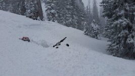
Med Bow snotel hit 60" with this storm cycle, more notably was the 4" SWE: at 12:1 snow:water that's 4' snow. It's deep out there. I took this picture earlier yesterday, then it nuked on us.
attachment.php

The riding was fantastic. Snotel went up 15" while we were riding, and drifted heavily. I know the range well, but with whiteout, in the dark (helmet light was clutch in deep snow), no trail marking or grooming, and some sled trouble, it took a while to get home. If you're heading up riding (especially before trails are in), go well prepared. I've never hit November conditions quite like this. We weren't that far from spending a night out there, despite being basically on N trail.

SnowiesNovemberResized.jpg
 
Nice to see the snow piling up out there and glad you and the other riders all made it home safe.

May be headed out there this Thursday thru Sunday. Picking up my new Doo 850 on Tuesday/Wednesday.
 
Premium Features


Back
Top