
<header class="entry-header"> “Parade of Storms” About to Clobber Western USA | Snow Totals Looking Ridiculous…
http://snowbrains.com/miracle-march...r-western-usa-snow-totals-looking-ridiculous/
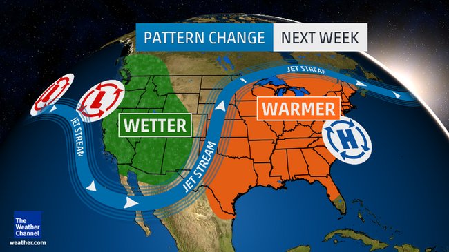
WeatherBrains | <time class="entry-date published updated" datetime="2016-03-01T11:54:10+00:00">March 1, 2016</time> | </header> <figure id="attachment_62232" style="width: 1536px;" class="wp-caption aligncenter"> <figcaption class="wp-caption-text">“As has been recently advertised, a more active storm track is becoming more likely and will result in widespread precipitation into this weekend and next week. The image shows the 7-day precipitation forecast across the West.” – NOAA, yesterday</figcaption></figure> NOAA and more are forecasting a BIG pattern change for the West Coast and the Western USA this week from hot and dry to cold and wet.
Some weather models are showing HUGE snowfall totals for the West Coast in the next 7 days and nearly all models are showing a very stormy month of March in the Western USA.
Miracle March is on its way!
<figure id="attachment_62245" style="width: 960px;" class="wp-caption aligncenter">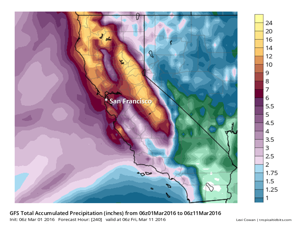 <figcaption class="wp-caption-text">The above model is showing somewhere around 8″ of liquid precipitation for Lake Tahoe, CA between now and March 11th – which, if it all came as snow, would translate to about 8-feet of snow….</figcaption></figure> California, Oregon, Washington:
Huge precipitation numbers and drowning snowfalls are forecast for the West Coast in the next week. Up to 5-8″ of liquid precipitation is forecast in spots in the next 7-days (which could translate to 5-8 feet of snow…).
Some weather models are forecasting up to 6-Feet of snowfall for Lake Tahoe, CA/NV above 8,000-feet by Monday…
Mammoth Mountain Weather Guy is forecasting 120-150″ of snowfall for Mammoth in the month of March.
<figure id="attachment_62246" style="width: 750px;" class="wp-caption aligncenter">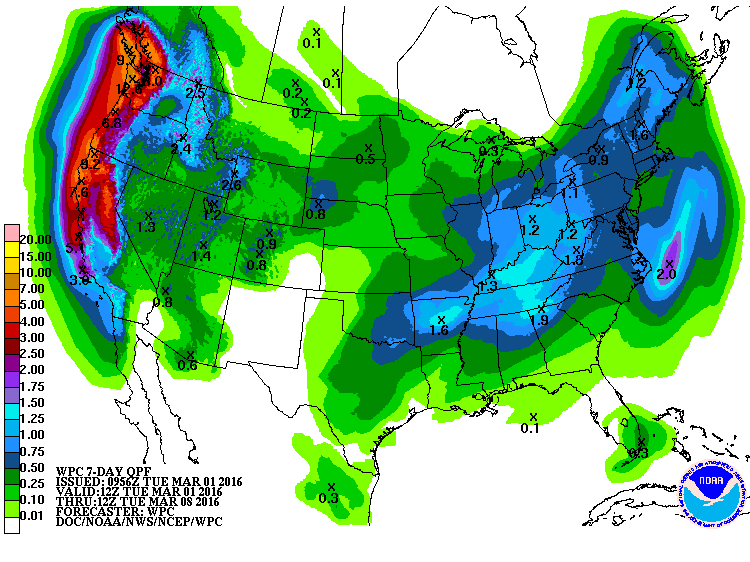 <figcaption class="wp-caption-text">7-day liquid precip totals in CA, OR, WA are looking huge and wild. image: noaa, today</figcaption></figure> Idaho, Wyoming, Montana:
Around 2.5″ of liquid precipitation is forecast in the next 7-days in the northern Rockies, which would translate to around 2.5-feet of snow is the mountains (Jackson Hole, Grand Targhee, Big Sky).
<figure id="attachment_62248" style="width: 2200px;" class="wp-caption aligncenter">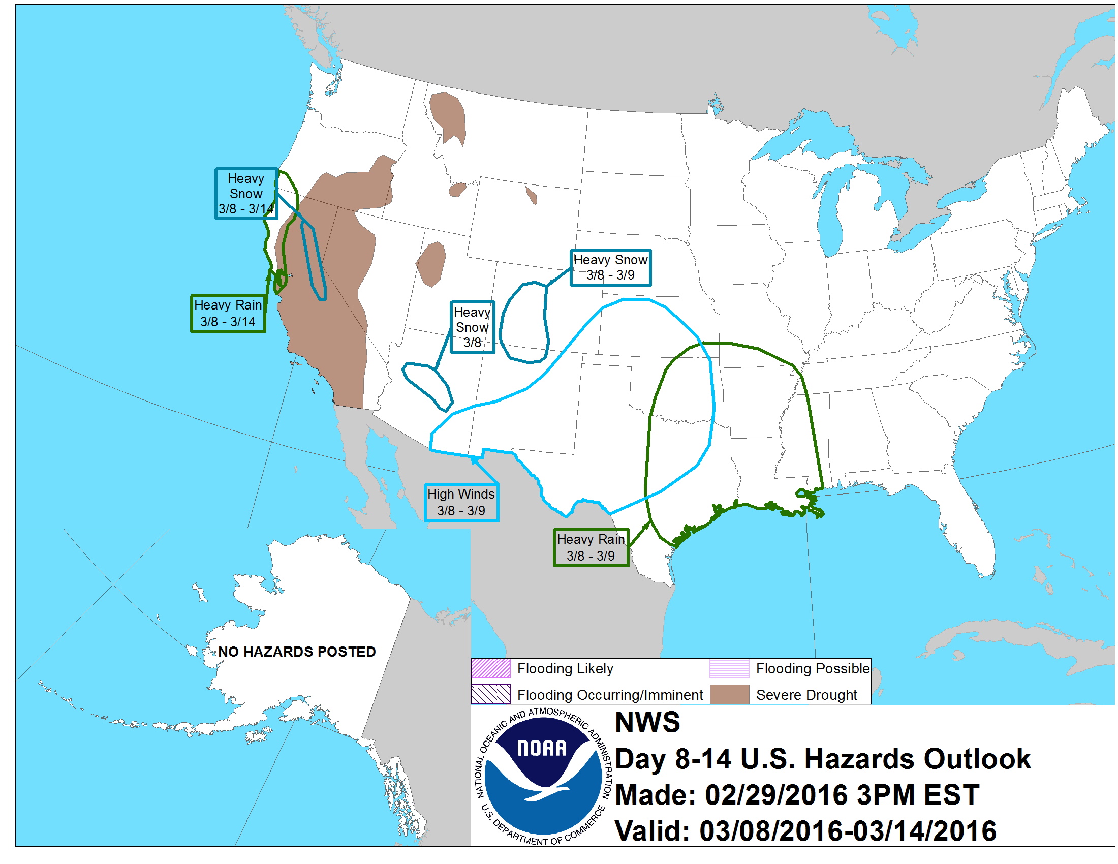 <figcaption class="wp-caption-text">Heavy Snow forecast in CO next week on March 8-9th. Heavy snow forecast in CA from March 8-14th. image: noaa, today</figcaption></figure> Colorado:
Looking like a snowy week next week with around .8″ of liquid precipitation forecast the next 7-days, which would translate to around a 8″ of snowfall in CO. Local forecasters are calling for even more…
<figure id="attachment_62240" style="width: 650px;" class="wp-caption aligncenter">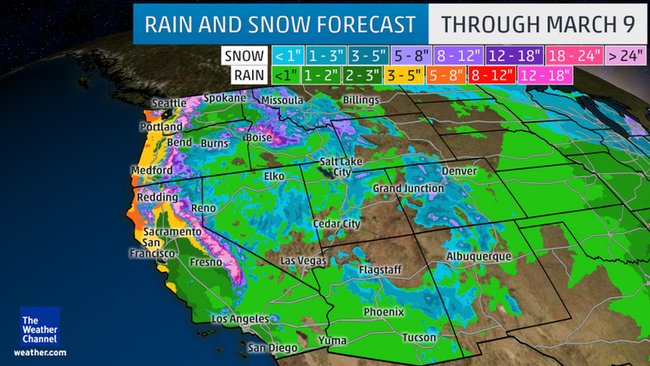 <figcaption class="wp-caption-text">Looking good for snow in the Western USA this week.</figcaption></figure> Utah:
NOAA is forecasting 1.2″ of liquid forecast for Utah the next 7-days which would translate to around 14″ of snowfall. Powder Mountain & Snowbasin look like they’ll do well in this cycle. Alta, Snowbird, Solitude, and Brighton always seem to get more snow than forecast…
MORE MIRACLE MARCH INFO:
 <figcaption class="wp-caption-text">Big pattern change coming to the Western USA this week.</figcaption></figure> <figure id="attachment_62247" style="width: 2200px;" class="wp-caption aligncenter">
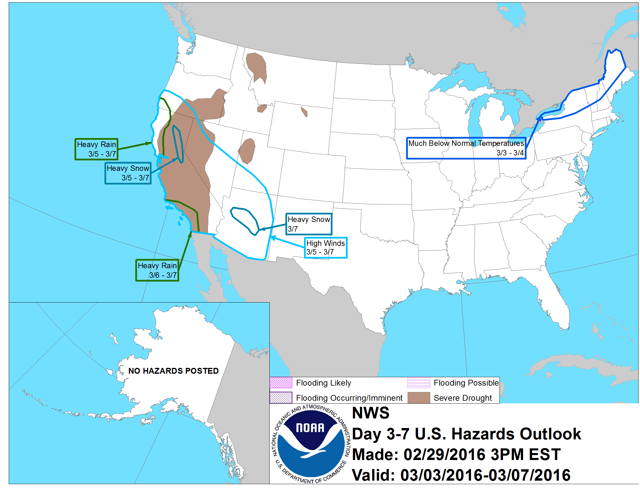 <figcaption class="wp-caption-text">Heavy snow forecast in CA on March 5-7th. Heavy snow forecast in AZ on March 7th.</figcaption></figure>
<figure id="attachment_62238" style="width: 815px;" class="wp-caption aligncenter">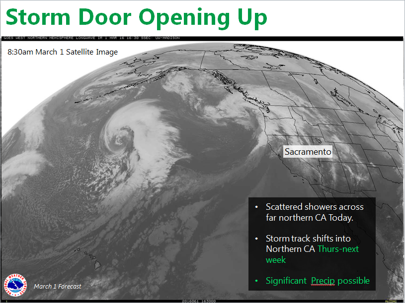 <figcaption class="wp-caption-text">“Major pattern change underway. Significant precipitation possible over NorCal from Thursday into next week.” – NOAA Sacramento, CA today</figcaption></figure> <figure id="attachment_62234" style="width: 960px;" class="wp-caption aligncenter">
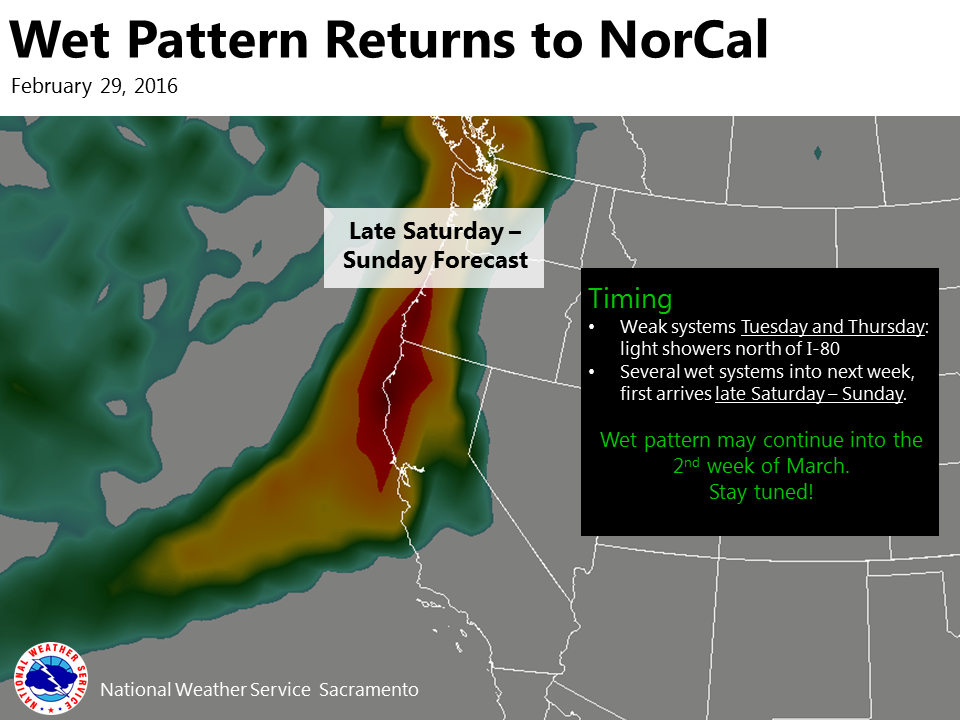 <figcaption class="wp-caption-text">“Wet weather could return to Northern California this weekend and may continue into the 2nd week of March!” – NOAA Sacramento, CA today</figcaption></figure> <figure id="attachment_62233" style="width: 1525px;" class="wp-caption aligncenter">
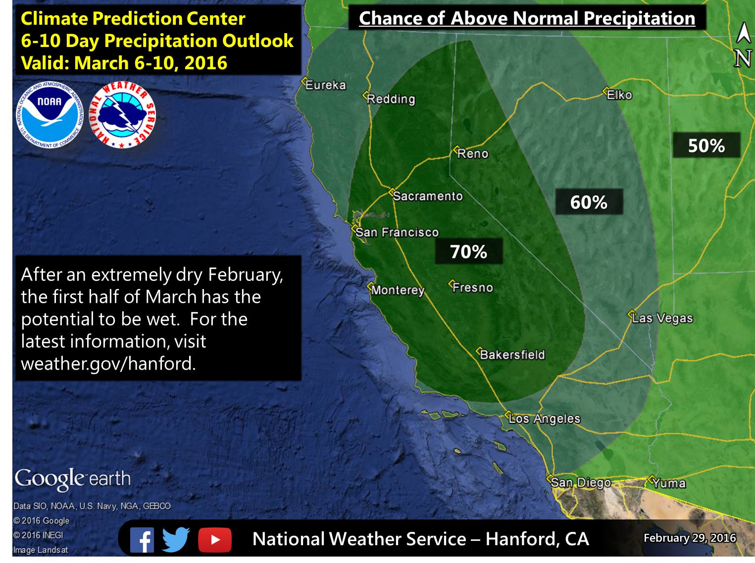 <figcaption class="wp-caption-text">“Confidence continues to grow for above average precipitation in early March.” – NOAA Hanford, CA today</figcaption></figure> <figure id="attachment_62242" style="width: 960px;" class="wp-caption aligncenter">
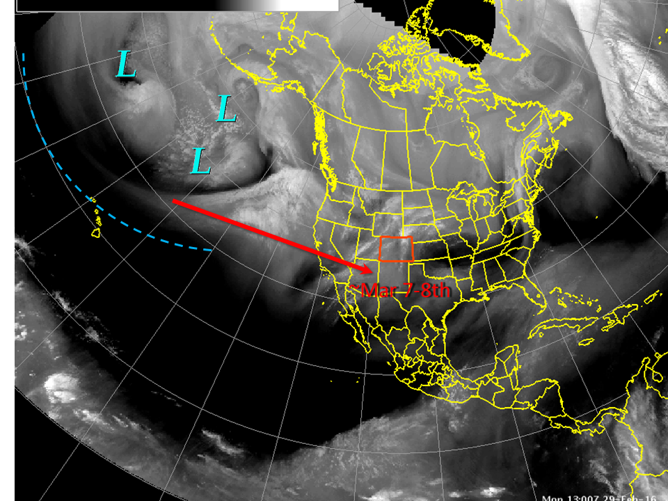 <figcaption class="wp-caption-text">“A lot of storminess in the central and north Pacific right now, seen in the water vapor image from thius morning, will slowly translate eastward until it reaches the Central Rockies sometime early next week. Then, expect a return to cool and unsettled conditons, maybe even some snow for the lowlands” – NOAA, Colorado yesterday</figcaption></figure> <figure id="attachment_62243" style="width: 713px;" class="wp-caption aligncenter">
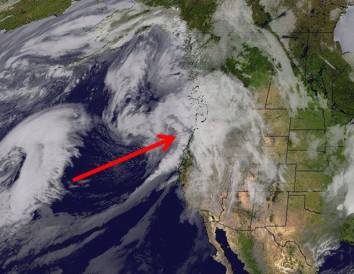 <figcaption class="wp-caption-text">“Here comes the moisture!” – NOAA Seattle, WA today</figcaption></figure> <figure id="attachment_62235" style="width: 884px;" class="wp-caption aligncenter">
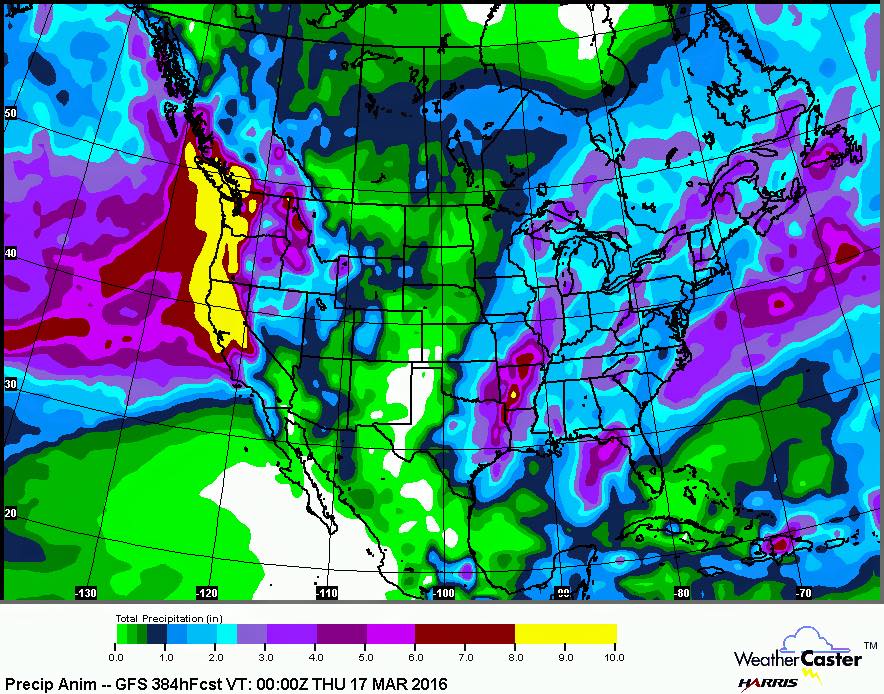 <figcaption class="wp-caption-text">“Our sleepy El Niño is back from its slumber to a more typical pattern. This early spring is about to receive a rude awakening! Beginning this weekend a series of storms will barrel in from the Pacific between then, and mid-March. Initially, the snow levels will be relatively high until the trough deepens the snow levels will then drop to perhaps below 2000 feet.” – ABC30 weatherman Kevin Musso, today</figcaption></figure>
Posted by
 WeatherBrains | <time class="entry-date published updated" datetime="2016-03-01T11:54:10+00:00">March 1, 2016</time>
http://snowbrains.com/miracle-march...r-western-usa-snow-totals-looking-ridiculous/
WeatherBrains | <time class="entry-date published updated" datetime="2016-03-01T11:54:10+00:00">March 1, 2016</time> | </header> <figure id="attachment_62232" style="width: 1536px;" class="wp-caption aligncenter">
<figcaption class="wp-caption-text">“As has been recently advertised, a more active storm track is becoming more likely and will result in widespread precipitation into this weekend and next week. The image shows the 7-day precipitation forecast across the West.” – NOAA, yesterday</figcaption></figure> NOAA and more are forecasting a BIG pattern change for the West Coast and the Western USA this week from hot and dry to cold and wet.Some weather models are showing HUGE snowfall totals for the West Coast in the next 7 days and nearly all models are showing a very stormy month of March in the Western USA.
Miracle March is on its way!
<figure id="attachment_62245" style="width: 960px;" class="wp-caption aligncenter">
<figcaption class="wp-caption-text">The above model is showing somewhere around 8″ of liquid precipitation for Lake Tahoe, CA between now and March 11th – which, if it all came as snow, would translate to about 8-feet of snow….</figcaption></figure> California, Oregon, Washington: Huge precipitation numbers and drowning snowfalls are forecast for the West Coast in the next week. Up to 5-8″ of liquid precipitation is forecast in spots in the next 7-days (which could translate to 5-8 feet of snow…).
Some weather models are forecasting up to 6-Feet of snowfall for Lake Tahoe, CA/NV above 8,000-feet by Monday…
“Can I go out on the limb and forecast 5-10 feet through the latter part of next week.” – Powderchasers.com, forecast for the Sierra Nevada, CA today
Brian Allegretto of Opensnow.com is forecasting 25-42″ of snow above 8,000-feet by Monday.
Mammoth Mountain Weather Guy is forecasting 120-150″ of snowfall for Mammoth in the month of March.
<figure id="attachment_62246" style="width: 750px;" class="wp-caption aligncenter">
<figcaption class="wp-caption-text">7-day liquid precip totals in CA, OR, WA are looking huge and wild. image: noaa, today</figcaption></figure> Idaho, Wyoming, Montana: Around 2.5″ of liquid precipitation is forecast in the next 7-days in the northern Rockies, which would translate to around 2.5-feet of snow is the mountains (Jackson Hole, Grand Targhee, Big Sky).
<figure id="attachment_62248" style="width: 2200px;" class="wp-caption aligncenter">
<figcaption class="wp-caption-text">Heavy Snow forecast in CO next week on March 8-9th. Heavy snow forecast in CA from March 8-14th. image: noaa, today</figcaption></figure> Colorado:Looking like a snowy week next week with around .8″ of liquid precipitation forecast the next 7-days, which would translate to around a 8″ of snowfall in CO. Local forecasters are calling for even more…
<figure id="attachment_62240" style="width: 650px;" class="wp-caption aligncenter">
<figcaption class="wp-caption-text">Looking good for snow in the Western USA this week.</figcaption></figure> Utah:NOAA is forecasting 1.2″ of liquid forecast for Utah the next 7-days which would translate to around 14″ of snowfall. Powder Mountain & Snowbasin look like they’ll do well in this cycle. Alta, Snowbird, Solitude, and Brighton always seem to get more snow than forecast…
MORE MIRACLE MARCH INFO:
(read the captions under each image for more detail)
<figure id="attachment_62236" style="width: 650px;" class="wp-caption aligncenter"><figcaption class="wp-caption-text">Big pattern change coming to the Western USA this week.</figcaption></figure> <figure id="attachment_62247" style="width: 2200px;" class="wp-caption aligncenter"><figcaption class="wp-caption-text">Heavy snow forecast in CA on March 5-7th. Heavy snow forecast in AZ on March 7th.</figcaption></figure> <figure id="attachment_62238" style="width: 815px;" class="wp-caption aligncenter">
<figcaption class="wp-caption-text">“Major pattern change underway. Significant precipitation possible over NorCal from Thursday into next week.” – NOAA Sacramento, CA today</figcaption></figure> <figure id="attachment_62234" style="width: 960px;" class="wp-caption aligncenter"><figcaption class="wp-caption-text">“Wet weather could return to Northern California this weekend and may continue into the 2nd week of March!” – NOAA Sacramento, CA today</figcaption></figure> <figure id="attachment_62233" style="width: 1525px;" class="wp-caption aligncenter"><figcaption class="wp-caption-text">“Confidence continues to grow for above average precipitation in early March.” – NOAA Hanford, CA today</figcaption></figure> <figure id="attachment_62242" style="width: 960px;" class="wp-caption aligncenter"><figcaption class="wp-caption-text">“A lot of storminess in the central and north Pacific right now, seen in the water vapor image from thius morning, will slowly translate eastward until it reaches the Central Rockies sometime early next week. Then, expect a return to cool and unsettled conditons, maybe even some snow for the lowlands” – NOAA, Colorado yesterday</figcaption></figure> <figure id="attachment_62243" style="width: 713px;" class="wp-caption aligncenter"><figcaption class="wp-caption-text">“Here comes the moisture!” – NOAA Seattle, WA today</figcaption></figure> <figure id="attachment_62235" style="width: 884px;" class="wp-caption aligncenter"><figcaption class="wp-caption-text">“Our sleepy El Niño is back from its slumber to a more typical pattern. This early spring is about to receive a rude awakening! Beginning this weekend a series of storms will barrel in from the Pacific between then, and mid-March. Initially, the snow levels will be relatively high until the trough deepens the snow levels will then drop to perhaps below 2000 feet.” – ABC30 weatherman Kevin Musso, today</figcaption></figure> Posted by


