POWDER UPDATE! CALIFORNIA DREAMING- COLORADO ON WATCH
03/09/2021
Please consider a
donation to Powderchasers for all of our forecasts this season.
The
Concierge is still open to new members looking to chase powder!
5AM wake up call are not easy especially when not chasing powder.
Summary:
The short-term forecast will chase to California for a wide area of 10-18 inches for many Ski Areas from Tahoe to Mammoth. The northern areas near Mt Shasta grab higher amounts. Colorado will be the top highlight this weekend.
Forecast: High confidence continues for a decent storm for the Sierra Range. Low pressure off the coast of California will track inland Tuesday night and spread good overnight snow to most of the Tahoe Basin including Mammoth to the south. Further north towards Shasta will see higher amounts Tuesday to Wednesday (Day and evening snowfall). Generally, the crest of the Tahoe Basin will see 12-16 inches above 7,000 feet with higher amounts possible towards Kirkwood and perhaps Mammoth.
The Good: Many Ski Areas in the Tahoe Basin grab much-needed powder. Good timing for powder for Wednesday morning. Cold temps, Moderate winds.
The Bad:? Has not snowed in Tahoe for a while.
Below:
Short Term HRR model showing high confidence for a wide area of 12-16 inches above 7,000 feet along the Sierra Crest by 9 AM Wednesday. Slightly higher amounts possible south of the Lake and well north of I-80.

Otherwise, storm chasing could be possible in the Rockies where deep snow is likely for the central portions of Wyoming (Snowmobiles), extending moderately towards the Laramie Ranges (Skiing). SW flow over Colorado will bring snow showers to the southern mountains Tuesday/Wednesday (Light) with the models pushing moderate amounts over Rabbit Ears Pass. The Wasatch also grabs a pesky pattern of light snow for the next several days (2-9 over 3-4 days) with higher amounts for the northern Uinta Range.
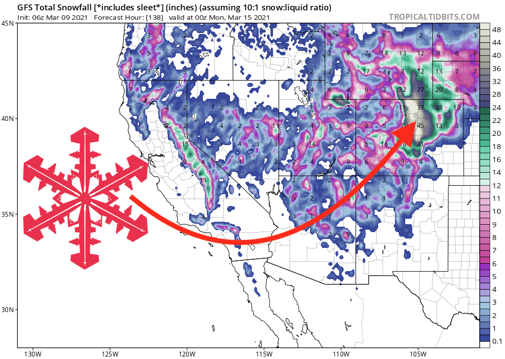
The end of the week still features a high confidence storm for Colorado with a storm tracking over the 4 corners by Friday. This will form a closed low initially with SW flow bringing several periods of light or moderate snow to the San Juan Range late this week into Saturday. Winds initially from the SW will favor the southern mountains initially. Currently, there are no single deep periods in any 12 hour period, with temps on the warm side. It is possible that Purgatory, Silverton, and even Telluride score 5-10 inches through this period. Significant moisture will set up north of the low tracking east over Denver for late Friday night into Sunday. Winds blow from the SE initially (Not common) before veering East (Upslope) and ending N, NE by late Saturday or Sunday. While the storm is still 4-5 days out I will try and summarize the latest data.
* Models show ample moisture for the Front Range Foothills (20-30 inches). Slight downtrend from yesterday.
*Highest totals will come from areas near or east of the Continental Divide (Eldora, A-Basin, Winter Park, Berthoud Pass, Georgetown). Strong East flow will also push some moisture into Summit County. Some decent amounts are possible for Breckenridge, Keystone albeit lower than areas east of the Divide. Other spots to watch per the model runs are Ski Cooper ( I called that one on the last storm), and Monarch (Wildcard sitting just west of the highest moisture ranges. Metro Boulder, Denver will see significant travel impacts late Friday through Sunday (Airport might grab 12-15 inches).
* West of the Divide will see lighter snow totals (I-70 from Summit to Vail) with the possibility of decent amounts for Aspen, Crested Butte, Telluride, Purgatory, or Silverton. Winds stay more SW in the southern mountains during this storm, so it is possible that while the Front Range gets clobbered, areas in the San Juan Range still report decent totals (Slow build-up of several periods of 2-5 inches).
Bottom Line:
This forecast will need to be updated as we get closer. Temps on this upcoming storm is not very cold west of the Divide (-8 to -9C at 10K) with colder air east of the divide. Quality in the San Juan ranges might lack at lower elevations. We may see too much snow for some resorts near the Front Range creating travel closures, lift impacts or point it straight conditions.
Where to chase? It's going to come down the wire.
Below.
Saturday- 5 PM MST. Temps at 10K feet are not very cold west of the Divide (-7, -8C) with denser snow possible. East of the Divide is in the -13C range especially in the northern Front Range from Boulder to Fort Collins. Higher temps west of the Divide might limit snow totals.
Powderchaser Steve
Please support Powderchasers by either joining the powder concierge or making a donation for our powder forecasts.
The Concierge gets you custom chase forecasts and travel tips. The donations are used to support our forecasts.
Please consider a donation to Powderchasers for all of our forecasts this season. The Concierge is still open to new members looking to chase powder! 5AM wake up call are not easy especially when not chasing powder. Summary: The short-term forecast will chase to California for a wide area of...
www.powderchasers.com