Install the app
How to install the app on iOS
Follow along with the video below to see how to install our site as a web app on your home screen.
Note: This feature may not be available in some browsers.
You are using an out of date browser. It may not display this or other websites correctly.
You should upgrade or use an alternative browser.
You should upgrade or use an alternative browser.
25 years of Snowfall Graphs in Island Park/West Yellowstone (peaks)
- Thread starter christopher
- Start date
V
volcano buster
Well-known member
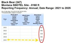
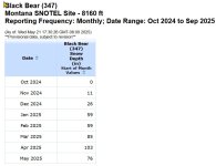
OKThe data is not the easiest to find...View attachment 433437View attachment 433439
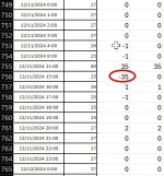
Since I have now done it be HAND, and now all the cell values up close and in person.
Please walk me through how you generated those numbers, as they are sooooo wildly different from what the actual individual hourly numbers total up to.

V
volcano buster
Well-known member
Beats me. I wish it made more sense because I just love poking buttons.
The more and deeper we dig into these numbers the more CURIOUS I am as to the REALITY.
HOW the heck do they "Compute" their SUM OF MONTHLY VALUES???
My number, 863 inches "SEEMS" crazy high.
But the math is solid and I KNOW exactly where it is coming from.
Their numbers, 323 inches "SEEMS" very reasonable to me
But the math and the Hourly/Daily snowfall totals do NOT support it??
HOW the heck do they "Compute" their SUM OF MONTHLY VALUES???
My number, 863 inches "SEEMS" crazy high.
But the math is solid and I KNOW exactly where it is coming from.
Their numbers, 323 inches "SEEMS" very reasonable to me
But the math and the Hourly/Daily snowfall totals do NOT support it??
OK, I think I see what they are doing now.
They are taking a depth measurement ONCE each day and then summing that over the course of the month.
I come up with...
Oct 2024= 11 Inches
Nov 2024= 38 Inches
Dec 2024= 41 Inches
Jan 2025= 17 inches
Feb 2025= 52 inches
Mar 2025= 41 inches
Apr 2025= 15 inches
May 2025= 15 inches
TOTAL SNOWFAL FOR SEASON = 230 inches
But sure enough, that does NOT match up with their "Snow Depth Sum of Monthly Values" = 323 inches !

Grrrr
are all these numbers just GARBAGE??????
They are taking a depth measurement ONCE each day and then summing that over the course of the month.
I come up with...
Oct 2024= 11 Inches
Nov 2024= 38 Inches
Dec 2024= 41 Inches
Jan 2025= 17 inches
Feb 2025= 52 inches
Mar 2025= 41 inches
Apr 2025= 15 inches
May 2025= 15 inches
TOTAL SNOWFAL FOR SEASON = 230 inches
But sure enough, that does NOT match up with their "Snow Depth Sum of Monthly Values" = 323 inches !

Grrrr
are all these numbers just GARBAGE??????
Last edited:
I’d say yes.
The numbers we pay closest attention to are the actual water content.
But even those are broad trends, not exact as we collect and record monthly snow samples for storage estimates.
Emphasis on estimates.
The numbers we pay closest attention to are the actual water content.
But even those are broad trends, not exact as we collect and record monthly snow samples for storage estimates.
Emphasis on estimates.
V
volcano buster
Well-known member
Pure speculation, but they have no real means to measure snow depth at a remote location.
They likely use a weight calculation to predict the depth.
If you have seen the sno-tel sites they have a panel scale to weigh a column of snow.
The differences in moisture content could alter the snow depth drastically. Whether they have calibrations for relative humidity and temperature when the snow falls would require some deeper digging. Otherwise, they would use a straight line calculation.
Snow depth is measured by electronic beam.
The snow pillows as you’ve seen calculate weight and density.
These are also cross checked using density tubes which are manual checks that are typically done once a month.
We have several manual depth and density sites that aren’t monitored by snotel but recorded by the state monthly.
The snow pillows as you’ve seen calculate weight and density.
These are also cross checked using density tubes which are manual checks that are typically done once a month.
We have several manual depth and density sites that aren’t monitored by snotel but recorded by the state monthly.
SNOTEL, Explained
Most weather stations in the United States are located at airports and in populated areas but most skiers and snowboarders enjoy powder in the high mountains far from official airport weather stations.In order to find weather and snowfall data in these more remote areas, we use SNOTEL sites.
How SNOTEL Sites Gather Snow Data
SNOTEL stands for SNOwpack TELemetry, which is a fancy name for a remote backcountry weather station that measures snow and transmits the data wirelessly. There are 730 sites dispersed throughout the western states of Washington, Oregon, California, Nevada, Idaho, Montana, Wyoming, Utah, Arizona, New Mexico, Colorado, South Dakota, and Alaska.
These sites are primarily focused on measuring snow depth and the amount of water contained in the snow.
The snow depth sensor shoots a beam down toward the snow, and this beam is then reflected back up. The sensor measures the time it takes for the beam to return to the sensor and calculates the snow depth hourly.

Each SNOTEL site consists of many sensors that measure snow and other weather conditions. These conditions are reported hourly through automated transmissions back to a central headquarters and are freely available online.
Using SNOTEL for Snowfall Data
Most skiers want to know how much new snow has fallen during a storm. Unfortunately, the SNOTEL sensors are only measuring the change in snow depth which includes the compacting and settling of the snow. This will return a lower number for the increase in "snow depth" during a storm vs the actual "snowfall" measured every 12 hours by ski areas. When measuring snowfall the spot is cleared after each measurement and the totals are added together. That is why the snow depth you experience when you get to the hill is usually less than the reported snowfall.
A more trustworthy measurement is called the snow water equivalent (SWE), which shows the amount of liquid that would be present if you melted a column of snow. A large rubber bladder is filled with antifreeze liquid and placed on the ground. As snow accumulates on the rubber bladder, the weight of the snow presses down and forces some anti-freeze liquid out of the bladder and through a measurement tube. Scientists correlate the amount of anti-freeze forced out of the bladder with the weight of the snow above.
This measurement is usually very accurate, but it does not provide the exact data skiers are looking for. Skiers can estimate new snowfall by multiplying the change in SWE by the assumed snow ratio which on average runs between 10-15:1. depending on the air temperature.
For example, if SWE increased by 0.5 inches during a storm, this could mean about 7.5 inches of new snow (15 x 0.5 = 7.5). This will only work if the storm was all snow and didn't switch to rain at any point during the storm.
Similar threads
- Replies
- 12
- Views
- 3K
- Replies
- 26
- Views
- 5K
- Replies
- 0
- Views
- 1K
- Replies
- 180
- Views
- 43K
D


