
TUESDAY SHOULD BE A GREAT DAY OF RIDING!
Install the app
How to install the app on iOS
Follow along with the video below to see how to install our site as a web app on your home screen.
Note: this_feature_currently_may_not_be_available_in_some_browsers
Island Park 20/21 Snow Conditions
- Thread starter christopher
- Start date
You are using an out of date browser. It may not display this or other websites correctly.
You should upgrade or use an alternative browser.
You should upgrade or use an alternative browser.

One more good storm for the Tetons, quiet pattern to follow

JACKSON, Wyo. — Jackson Hole is experiencing a nice storm cycle during the first few days of 2021. The first storm produced 6-12 inches of low-density snow in the Tetons on Saturday, and a second storm deposited another 5-8 inches of snow on Sunday.
Jackson Hole Mountain Resort’s Rendezvous Bowl Plot recorded 18 inches of total snowfall from Saturday morning through Monday morning. Skiing conditions are good right now with soft snow and snowpack that is right around average. Enjoy the new snow while you can, because it’s looking like conditions will dry out heading into mid-January.
Next storm to bring more snow from Monday night through Tuesday
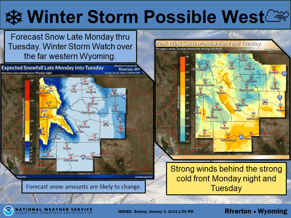
The third and final storm of this cycle looks like it will be the strongest one yet. The National Weather Service in Riverton has issued a Winter Storm Warning for the Teton and Gros Ventre Mountains from 3 p.m. on Monday through 3 p.m. on Tuesday and a Winter Weather Advisory for the Jackson Hole Valley.
Ahead of the storm, we’ll see a break during the day on Monday with mostly cloudy skies and warmer temperatures – highs in the mid 30s in the valley and mid 20s at 9,000 feet.
Snow showers will arrive late in the day before giving way to heavy snow on Monday night along with strong southwest winds. A cold front will arrive early Tuesday morning, with winds shifting to northwest and remaining strong throughout the day Tuesday.
The heaviest snowfall rates will occur overnight Monday night with light to moderate snow showers continuing throughout the day on Tuesday. The most difficult travel conditions are expected during the Tuesday morning commute.
Total snowfall from Monday night through Tuesday afternoon will range from 7-14 inches in the Tetons and 3-6 inches in the Jackson Hole Valley.

Tuesday is looking like a nice powder day for skiers at the resorts. However, dangerous avalanche conditions are expected due to new snow, density changes, strong winds and pre-existing weak layers. Be sure to check the Bridger-Teton Avalanche Center Forecast for the latest conditions.
Drier pattern expected heading into mid-January
While we’re experiencing a nice pattern for snowfall right now, unfortunately for skiers and snow enthusiasts, Monday night’s storm might be the last good storm for a while as the pattern turns less favorable.
Another weak system will bring some light snow on Thursday, and there’s a chance we could be brushed by another weak system on Saturday or Sunday as well.
However, the overall pattern will become less conducive to heavy or consistent snowfall heading into the week of January 10-17 as high pressure becomes the dominant feature across the Western U.S. Not a good look during a time of year when we expect consistent snowfall in the Tetons.

Forecast pattern for the second week of January shows a ridge of high pressure setting up over the Western U.S. Source: weathermodels.com
We may occasionally see a weak storm break through the ridge of high pressure with light snow chances during this period, but the potential for anything more than light snow is low.
Hopefully, we’ll get back into a more active pattern heading into late January. In the meantime, enjoy the snow we’re getting right now before this mid-January dry spell takes hold.

One more good storm for the Tetons, quiet pattern to follow
Jackson Hole Mountain Resort's Rendezvous Bowl Plot recorded 18 inches of total snowfall from Saturday morning through Monday morning.
 buckrail.com
SnowBrains Forecast: 12-18″ For Grand Targhee and Jackson Hole, WY Through Tomorrow
Eric McNamee | January 4, 2021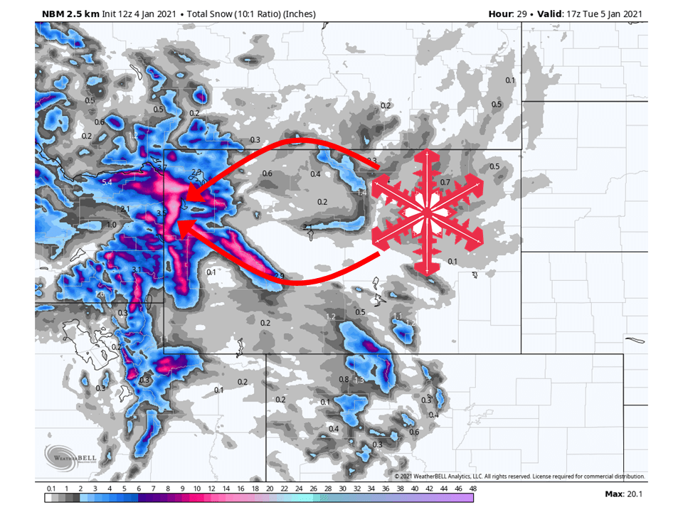
NBM Wyoming Snowfall Map Through 1/4/2021. Source: maps.weatherbell.com
Forecast By SnowBrains Meteorologist – Eric McNamee
10:15 AM MST, 1/4/2021
Brought to you by Grand Targhee
Forecast Summary:
A quick-hitting shortwave trough will bring 12-18″ of snow along the Tetons in Wyoming through tomorrow.This will lead to heavy snowfall for both Grand Targhee and Jackson Hole Ski Resorts during the day tomorrow.
By Wednesday a ridge of high pressure will build over the Western US, with some weak shortwave troughs moving through the remainder of the forecast period.
Short-Term Forecast:
Monday-Wednesday:
A shortwave trough will move through the Western US today and tomorrow, bringing 12-18″ of snow to the Tetons.Snow will get started later tonight as the shortwave approaches the regions and continues through the day Tuesday.
This is due to high amounts of moisture from the Pacific slamming into the Tetons, helping to force orographic lift across the area.
The National Weather Service has issued a Winter Storm Warning for the Tetons and surrounding mountain ranges because of this.
By Wednesday a ridge of high pressure will build over the Western US and dry conditions out.
A trough will move onshore over the West Coast today, with snow
returning over western portions ahead of this system. The associated
cold front is expected to push into western Wyoming by this evening
and quickly move across the rest of the area through Tuesday
morning. There will be strong forcing across the west tonight,
shifting across the rest of the forecast area Tuesday. Significant
snowfall continues to be likely over western portions and expect the
heaviest snowfall to occur through the overnight hours tonight. Have
upgraded the Watch to Winter Storm Warnings and Winter Weather
Advisories, as a result. There will be a chance for snow across
northern and southern portions early Tuesday morning, as the cold
front moves across these areas. These chances will spread southward
east of the Divide after daybreak, as the cold front exits the
forecast area. Minor snowfall accumulations are likeliest over
Natrona and portions of Johnson counties. There will also be a
window of snow turning to rain (or a rain/snow mix) for a few hours
early Tuesday afternoon. This could turn travel conditions
hazardous, as temperatures return to freezing by sunset. Also expect
very windy conditions Tuesday, as there are very strong pressure
rises in the wake of the cold front. The strongest winds look to
occur across northern Johnson County and Sweetwater County. High
winds are still a possibility in these areas, but do not look likely
at this time.
-NWS Riverton 1/4/2021
Long-Term Forecast:
Thursday-Sunday:
The ridge of high pressure mentioned above will remain in place over the west through the weekend, with some weak shortwave troughs moves through.Relatively light snowfall is expected out of these shortwaves at this time.
Extended Forecast:
Sunday and Beyond:
Global ensembles are indicating below-average precipitation and above-average temperatures are possible over most of the Western US through the extended period.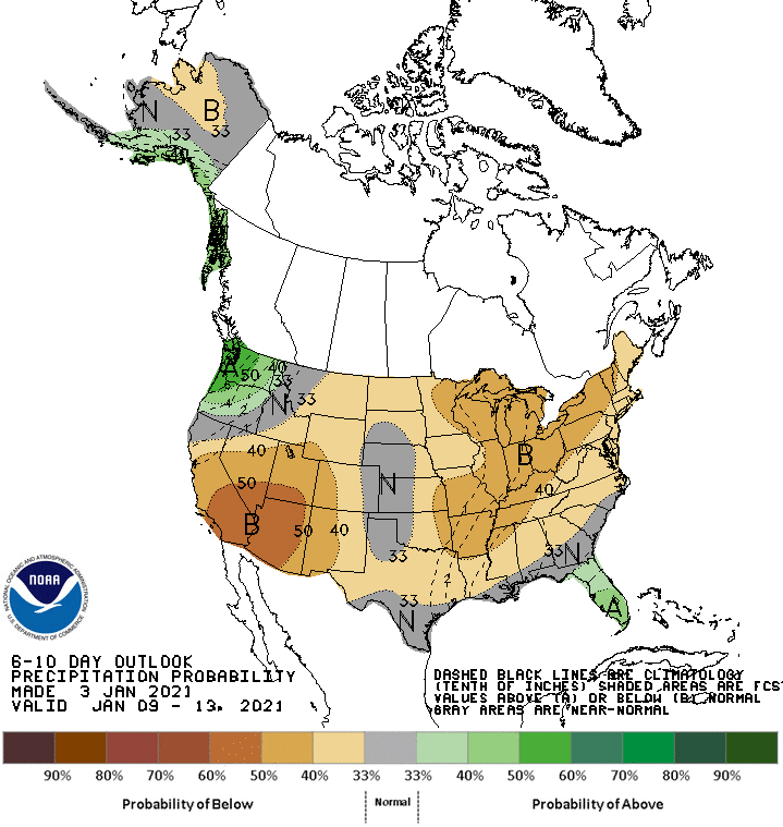
6-14 Day Probability of Precipitation Outlook. Source: NOAA
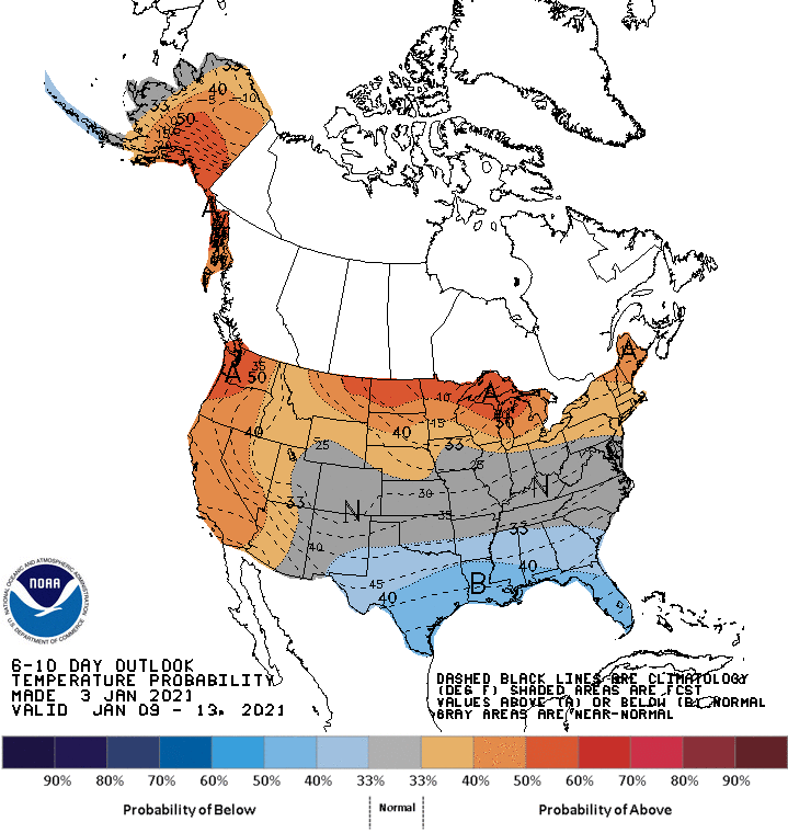
6-14 Day Probability of Temperature Outlook. Source: NOAA
SnowBrains Forecast: 12-18" For Grand Targhee and Jackson Hole, WY Through Tomorrow - SnowBrains
Forecast By SnowBrains Meteorologist – Eric McNamee 10:15 AM MST, 1/4/2021 Brought to you by Grand Targhee Forecast Summary: A quick-hitting shortwave trough will bring 12-18″ of snow along the Tetons in Wyoming through tomorrow. This will lead to heavy snowfall for both Grand Targhee and...
 snowbrains.com
AVALANCHE WARNING - 5 AM Tuesday, Jan 5 2021
The Gallatin National Forest Avalanche Center is issuing a Backcountry Avalanche Warning for the Bridger Range, Southern Gallatin Range, Southern Madison Range, the Lionhead area near West Yellowstone and the Centennial Range near Island Park, ID.
8-10” of snow overnight with strong wind are overloading a weak snowpack, creating very dangerous avalanche conditions.
Natural and human triggered avalanches are likely. Avalanche terrain and avalanche runout zones should be avoided.
The avalanche danger is rated HIGH on all slopes.
Contact the Gallatin National Forest Avalanche Center for more detailed information.
Website: www.mtavalanche.com
Avalanche Hotline: 406-587-6981
This warning will expire or be updated by 6:00 a.m. on Wednesday, January 6, 2021.
https://www.facebook.com/ryeguy14?_...A1NhPia-ejYVbfh-LRe8Ply3PsQ&__tn__=<,P-y0.g-R
![134929786_10159098671380030_3574962370905925668_n[1].png](https://www.snowest.com/forum/data/attachments/309/309206-0523a048ca6d26de46aa2832076066ec.jpg "134929786_10159098671380030_3574962370905925668_n[1].png")

i hope there is some systems coming in soon. we dont have any snow in mn either and i have 2 new sleds with 0 miles
we have snow at last!i hope there is some systems coming in soon. we dont have any snow in mn either and i have 2 new sleds with 0 miles
Meh... nothing to write home about

Spent the day riding in the tetons outside of Driggs yesterday
Snow was EXCELLENT.
Snow was EXCELLENT.
Yeah, seems south of IP is where it's at, Rode near Squirrel a month ago, had more snow than IP has now


Sent from my iPhone using Tapatalk
i seen some data that predicts snowy period starting next wed for a week
i seen some data that predicts snowy period starting next wed for a week
Hope your right
Last I checked we were in for a period of warming and dryness.
Shouldn’t last to long though.
Sent from my iPhone using Tapatalk
Another thin dusting coming.
![135856121_3856292221058350_4925208588282394775_n[1].png](https://www.snowest.com/forum/data/attachments/309/309422-78a45a0b2eca6db194958e9bf43ddf98.jpg "135856121_3856292221058350_4925208588282394775_n[1].png")
B
We are heading out to I.P. on Saturday the 16th (week from now) just hoping you guys leave some POW for us Flat-landers to play in.
A wet, windy, and warm Pacific storm will bring snow and rain to elevations below 7000 feet, and nearly all snow above that elevation.
A Winter Weather Advisory has been issued from Tuesday afternoon through Wednesday evening for the Ketchum-Sun Valley area and the Stanley basin and Sawtooths. Elsewhere, it will be a light snow with rain mixed in to make for sloppy conditions for travel.
The snow will melt in the eastern Magic Valley and most of the Snake River plain as temperatures get to 50 degrees in Burley and 45 degrees in Pocatello Wednesday afternoon.

So
this is our normal MID-WINTER MELT.
Everything low will melt off, and whats up high HOPEFULLY will be saved...
Thurday looks like our best shot for a good day of riding this week!!

A Winter Weather Advisory has been issued from Tuesday afternoon through Wednesday evening for the Ketchum-Sun Valley area and the Stanley basin and Sawtooths. Elsewhere, it will be a light snow with rain mixed in to make for sloppy conditions for travel.
The snow will melt in the eastern Magic Valley and most of the Snake River plain as temperatures get to 50 degrees in Burley and 45 degrees in Pocatello Wednesday afternoon.
So
this is our normal MID-WINTER MELT.
Everything low will melt off, and whats up high HOPEFULLY will be saved...
Thurday looks like our best shot for a good day of riding this week!!
US National Weather Service Pocatello Idaho
12:04 PM 1/13: A strong cold front is entering Idaho from Montana, extending from Mondia Pass to Island Park.The front will move southeast across the Upper Snake Plain this afternoon.
This front will produce locally heavy snow, strong winds and low visibility. #idwx
![136452579_3870440306310208_9175751611271248933_n[1].jpg](https://www.snowest.com/forum/data/attachments/309/309864-3cc4d19cbdae1e3c774388a8ce6dd919.jpg "136452579_3870440306310208_9175751611271248933_n[1].jpg")
=AZU2GhxjVPT_1XG8GoSYDhMwSVItnPPXRKkQcdqIT0xo7Nv4RGywp9-X5OspuOO6Q1waF2IqZHv3frzkOZ6P88N02E9EYqLIFoiwvqzdJgG4l8YW5YW2Ii5pqvgsU2tw3AzJ9fP6D2ZEMlGnWXlcrV1CsXYvjfX2xwMhttP3aTwMyEjFbDXZgyVFr_aYewZodveUzIeTvjZnbEPKUW29i0UTo52MJD-YJ52KSSqVK7Md8A&__tn__=-UC%2CP-R']Friends of the Gallatin National Forest Avalanche Center
In the last 2 days the mountains around Bozeman and Big Sky got 3” with 8-12” around West Yellowstone and Cooke City.
Yesterday’s gale-force wind scoured ridgetops and loaded slopes at all elevations and aspects.
Snow was redistributed with no predictable pattern.
The snowpack is weak and the recent snowfall and wind-loading has made it unstable.
Today is a day to avoid avalanche terrain.
Evidence continues to show that new snow, even a few inches, has a nasty habit of avalanching.
New drifts are packed densely and will crack and avalanche. For today, the avalanche danger throughout our forecast area is rated CONSIDERABLE on all slopes since triggering avalanches is likely.
Read the full forecast: https://www.mtavalanche.com/forecast
#GetTheForecast #KnowBeforeYouGo
Photo: Avalanche in Lionhead
![139503331_10159121263430030_5063629268436846178_o[1].jpg](https://www.snowest.com/forum/data/attachments/309/309921-1a0721b3d2d498e6171961a887b945fc.jpg "139503331_10159121263430030_5063629268436846178_o[1].jpg")

Similar threads
- Replies
- 523
- Views
- 43K
- Replies
- 452
- Views
- 32K
- Replies
- 185
- Views
- 22K
- Replies
- 0
- Views
- 5K