• Don't miss out on all the fun! Register on our forums to post and have added features! Membership levels include a FREE membership tier.

Bearclaw Bob's, second posting

Thread Rating
5.00 star(s)

bearclawbob

Well-known member
Lifetime Membership
Nov 27, 2007
1,525
1,095
113
SNOW

So far the snowman has been right. The mountain has picked up 8-10 inches of fresh powder. We've picked up about 5 inches of wet and heavy snow in town. The winter storm warning is still in effect till Friday midnight. For Saturday will be partly cloudy skies and lower 40's. The Sunday and Monday more snow moving back into the forecast.
I would like to thank MOM's Motorsports again for coming and staying with us. Jacob, thanks for riding with us yesterday. It was a great day.

AVALANCHE CONDITIONS: The current weather pattern will create a variety of avalanche problems today. On mid to low elevation slopes, above freezing temps and rain will increase the wet snow avalanche hazard. The thick surface crust that formed the past few days will hold up this morning, but the snowpack will become soft and unsupportable as the day progresses, mainly on slopes below 8,000 ft. This problem will be most dangerous in steep terrain, primarily in areas associated with terrain traps such as creek beds and gullies.

On upper elevation slopes, the dry snow avalanche hazard will increase as snow continues to fall. Dry loose avalanches in steep terrain will be the main concern. The firm crust below the new snow will make a good surface for the new snow to slide on. These slides have the potential to entrain a large volume of snow, which can carry a skier or rider into hazardous terrain.

Wind slabs below upper elevation ridgelines will also be a concern. Winds blew 20-30 mph out of the W-SW yesterday, which likely loaded leeward slopes. A recent avalanche outside of Cooke City is a good example of what’s still possible in steep, wind loaded terrain.

Today, the dry snow avalanche hazard will start out MODERATE, but rise to CONSIDERABLE with continued snowfall. The wet snow avalanche hazard on mid to low elevation slopes is MODERATE.
 

bearclawbob

Well-known member
Lifetime Membership
Nov 27, 2007
1,525
1,095
113
partly cloudy

Morning from Bearclaw/ bakery and the Super 8 motel. Most of the snow storm went North of us. The mountain picked up about 12 inches total from the storm. The snowman is still calling for a winter storm watch until midnight tonight.

Tomorrow will be the last day for the bakery to be open. Terri will be back open the end May.

Sunday will be my last day for the season. If you need something you can always call me. I'll try and help you as much a possible. I'll see everyone next season.

AVALANCHE CONDITIONS: Although the new snow had a day to settle and bond to the underlying bed surface, loose snow avalanches will be possible in steep terrain today. This problem will be a growing concern once the sun comes out. Pay attention to changing conditions and don’t be afraid to change plans if instability is on the rise.

An additional problem will be wind slabs near upper elevation ridgelines. Winds shifted to the E-NE yesterday, which will create unusual loading patterns. With plenty of snow available for transport, mainly above 9,000 ft. wind slabs will be something to look out for. These won’t be real touchy to human triggers, but they could to fail under the weight of skier or rider.

Today, the dry snow avalanche hazard is MODERATE in upper elevation terrain. The wet snow avalanche hazard will start out LOW, but rise to MODERATE as the day progresses.
 

bearclawbob

Well-known member
Lifetime Membership
Nov 27, 2007
1,525
1,095
113
Sunny

Mom's group left and they had a great time and so did we.
It's a bright day here in Cooke city. Let you guys know that Steve and Belinda the managers have left us to go back home to Ohio. We'll miss them. I'm sure a lot of our customers will. The new managers are Jennifer and Guy.
The snowman is calling for a nice day today, but things will change for Sunday through Tuesday. We will have a chance of snow. For Wednesday through Friday the sun comes back out and be a great day to play on the mountain.
Today was the last day for the bakery. Terri will be open the 3rd weekend of May. We will all see you then.

I do want to thank everyone that has come to town to ride, hike, ski or just visit to have a wonderful summer. If it wasn't for you folks, this little town wouldn't be here. Again a Big Thank you.

AVALANCHE CONDITIONS: Today, wet loose avalanches will be the primary concern. The snow that fell Wednesday night and Thursday morning will move easily when exposed to direct sun and warming temps. Yesterday, my partner and I took a final tour up Hyalite and found 8” of new snow above 9,000 feet. The new snow was dense and contained more than 1” of SWE. Alex found similar conditions in the mountains around Cooke City yesterday.

The new snow is sitting on a firm ice crust, which will make a good sliding surface. Wet loose avalanche have the potential to entrain large volumes of snow and run long distances. Watch for signs of instability such as roller balls and pinwheels. These are obvious clues the surface snow is losing strength and becoming unstable. Moving to shadier aspects or away from steep slopes will be a good idea if these signs are present.

A secondary avalanche problem will be wind slabs. Moderate to strong winds out of the E-NE formed wind drifts below upper elevation ridgelines. Yesterday, a skier on Mt Blackmore remotely triggered a wind slab that broke 1’ deep and 30 feet wide. This slide could have caught and carried the skier into hazardous terrain. Be especially aware of this problem is you’re seeking dry snow on high north facing slopes.

Today, the wet snow avalanche danger will start out LOW, but rise to CONSIDERABLE as the day heats up. The dry snow avalanche danger is rated MODERATE on upper elevation-wind loaded slopes.
 

bearclawbob

Well-known member
Lifetime Membership
Nov 27, 2007
1,525
1,095
113
Side x side

If you plan on coming out this summer. We do rent Single atv's, side x sides, 4 passenger and 5 passenger units. Stop by and say HI if your in town. Have a great summer.
 

bearclawbob

Well-known member
Lifetime Membership
Nov 27, 2007
1,525
1,095
113
snow

Had to let you guys know how good the riding has been. Excellent

Don't miss out on the best riding, I think for this whole winter. Fresh snow and a great base. The snowman is still calling for more snow for the weekend.
 

bearclawbob

Well-known member
Lifetime Membership
Nov 27, 2007
1,525
1,095
113
road opening

The park has the equipment on site last Thursday. Looking on opening the road starting Monday east of town to the parking lot. If no problems, they should have the road open by the weekend.
 

bearclawbob

Well-known member
Lifetime Membership
Nov 27, 2007
1,525
1,095
113
Great weekend

It was a great turn out for the Avalanche ride this weekend. Lots of people showed up. Riding is not to bad. I'm headed out on the mountain this afternoon.
 

RMK-King

Super-Moderator
Dec 25, 2007
1,928
1,374
113
North Dakota
Still plenty of snow left for one last spring ride. Beartooth pass is also open now.
24d3a205121809b5e791806f1549ff4d.jpg
bab73eb467e913ad39d1644c64426f94.jpg


Sent from my SM-G900V using Tapatalk
 

bearclawbob

Well-known member
Lifetime Membership
Nov 27, 2007
1,525
1,095
113
still snowing

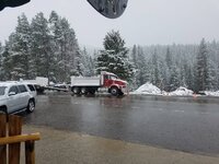
Morning on this snowy morning from Cooke city. If your still looking for a place to ride, its here. You have to go up about half of a mile up LULU, but then you can take off to ride. At this time we are getting light snow. Attached is a picture for June 13. This will close Beartooth passe again.

20170613_070240 (1).jpg
 
Premium Features