• Don't miss out on all the fun! Register on our forums to post and have added features! Membership levels include a FREE membership tier.

NS1 Gauge System with GPS Mapping

I

izzni

Well-known member
Mar 22, 2009
736
513
93
Vadnais Heights
After a couple seasons of development and testing the NS1 is finally available! It has been available since early November, but limited availability has kept me from annoucing it on Snowest until now.

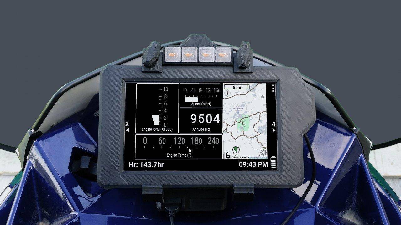
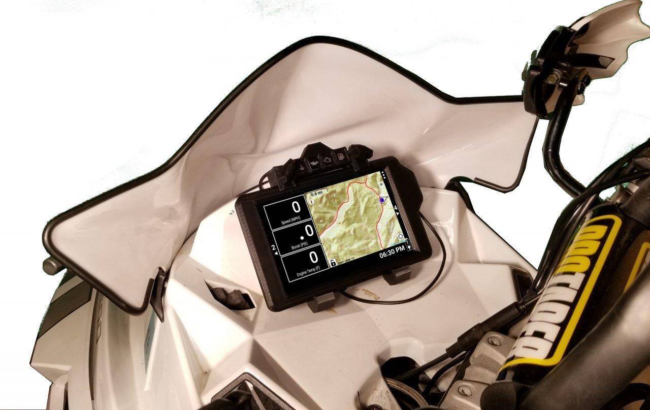
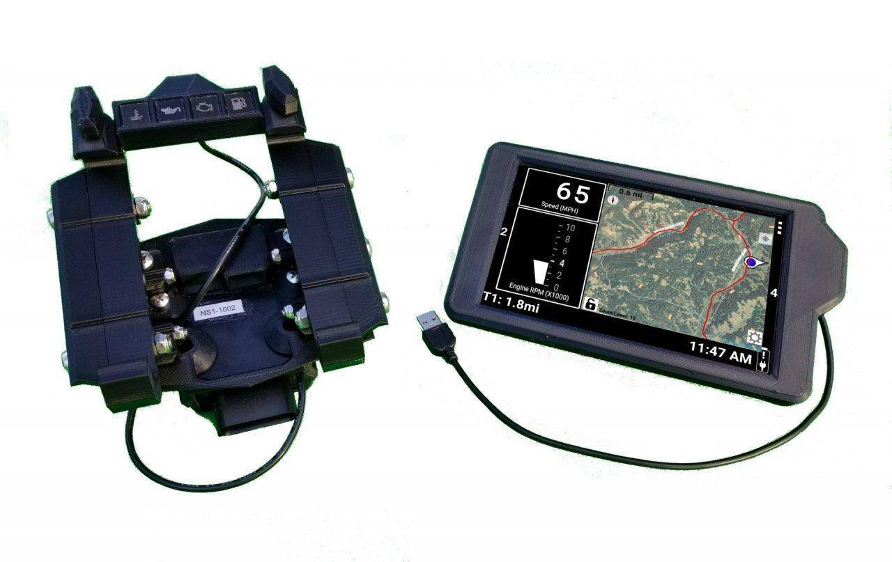
The NS1 Gauge System is a complete replacement for the stock gauge on both Arctic Cat and Polaris sleds. It has a detachable 7 inch Android based display that you can take inside and plan routes, download maps, or get updates from your couch. You can choose from a wide variety of gauge faces including horizontal bar and needle graphs, vertical needle and bar graphs, circular needles faces, and text faces. Each of these gauge faces comes in a variety of sizes. The gauge system even has inputs to show AFR and Boost.

It has advanced GPS mapping capabilities that allow you can display street maps, aerial imagery(US only), and overlay elevation contour lines (US only). These features set this gauge system apart from any existing gauge system, including the Polaris IDD, and make it a true replacement for the standalone GPS unit that many mountain riders rely on.

Trail maps for Minnesota, Michigan, New York, and Wyoming are pre-loaded on the gauge. Wisconsin, Maine, New Hampshire, and North Dakota trail maps are available if you purchase Redpinemapping.com's GPS Sled Maps USA. In addition, limited Garmin map support is available, with more advanced support scheduled for late this season.

The NS1 Gauge System will also have the ability to Data Log and graph the collected data right on the NS1 Display. Data will be automatically recorded, and well over 50 hours of data can be stored. This feature will be available within the next couple weeks.

You can find more information on the NS1 Gauge System's features, along with how to pre-order, here:
NS1 Gauge System - Next Stage Gauges

The documentation for the NS1 Gauge System, including the Installation Manuals and User Manual, can be found here:
Documentation - Next Stage Gauges

If you have an Android tablet or phone you can test drive the NS1 Dashboard App, which is the App that runs on the NS1 Display:
NS1 Dashboard App


picture.php


picture.php


picture.php


.
 
Last edited by a moderator:

The Bob

Well-known member
Premium Member
Mar 1, 2008
504
84
28
MN
Wow, I am not sure its for me. But I could really see this being a good thing for avid touring folks. Durability would be my issue as I am hard on things and still have a "go big" attitude, haha. But the big screen and such makes it ideal for someone like my father (in his 70's and loves going for miles).

Honestly what really blew me away was the price. I figured you'd be at a price double what they are. Nice.
 
I

izzni

Well-known member
Mar 22, 2009
736
513
93
Vadnais Heights
I'm curious about adding (for example) Garmin topo maps.

I don't have plans to support Garmin topographical maps, but I do plan to more fully support Garmin maps in general.

Right now the extent of the Garmin map support is showing trails. It has been tested with Redpinemapping's GPS SledUSA, although it will handle most trail only Garmin maps as well. Trail names, waypoint names, and styles of trails and waypoints won't be supported until after this season.

The reason I won't be supporting Garmin topographical maps is that there is perfectly good topographical maps already available for the NS1.

picture.php


picture.php


picture.php


.
 
Last edited by a moderator:

LongHorn XC

Well-known member
Lifetime Membership
Nov 27, 2007
702
285
63
Illinois
I don't have plans to support Garmin topographical maps, but I do plan to more fully support Garmin maps in general.

Right now the extent of the Garmin map support is showing trails. It has been tested with Redpinemapping's GPS SledUSA, although it will handle most trail only Garmin maps as well. Trail names, waypoint names, and styles of trails and waypoints won't be supported until after this season.

The reason I won't be supporting Garmin topographical maps is that there is perfectly good topographical maps already available for the NS1.

USGS%20Topo%20Aerial.jpg


USGS%20Topo%20Only.jpg

When updates/changes are made, are you going to provide them free for years to come?
 

likkerpig

Well-known member
Lifetime Membership
Nov 28, 2007
1,298
271
83
I got broken links on the topo map reply... Wasn't aware it came with those preloaded. Thanks for the info!
 

Ron Burgandy

Well-known member
Lifetime Membership
Dec 21, 2012
394
136
43
I will be providing software updates for free, although hardware updates will not be free. I'm actually about to publish today the update that adds data logging.


Is this device portable? As in can I use this on my sled during winter and come summer use it on my rzr via a different docking system?


Sent from my iPhone using Tapatalk
 
I

izzni

Well-known member
Mar 22, 2009
736
513
93
Vadnais Heights
The aerial imagery and topo maps are not preloaded, but instead loaded through the Area Caching feature. This allows you to download the aerial and topographic maps for your area and use them offline.
 
Last edited by a moderator:
I

izzni

Well-known member
Mar 22, 2009
736
513
93
Vadnais Heights
Is this device portable? As in can I use this on my sled during winter and come summer use it on my rzr via a different docking system?


Sent from my iPhone using Tapatalk

The NS1 Display can definitely be moved from vehicle to vehicle. Unfortunately I do not have complete support for the RZR at the moment. The software and firmware are there, but I don't have a mount that would work for that vehicle.
 
I

izzni

Well-known member
Mar 22, 2009
736
513
93
Vadnais Heights
NS1 Gauge System Data Logging Now Available

Recently I published an update to the NS1 Gauge System that adds data logging functionality. The data logging happens automatically in the background, and a new log is created whenever any of the following happen:
-The NS1 Dashboard App is started
-The sled has stopped for 15 minutes
-The "Start New Data Log" button has been touched

The NS1 User Manual has been updated so that it explains how to use the Data Logging functionality. You can find the updated NS1 User Manual here:
NS1 User Manual

For those who like to play around, the Data Logging Functionality can be found by touching the settings button in the upper right corner of the screen, and selecting "Data Logging". The graph showing the data can be panned and zoomed by swiping, pinching, and stretching gestures, just like a picture on a smartphone.

Here's an example of what the data logging functionality looks like:
picture.php


.
 
Last edited by a moderator:

LongHorn XC

Well-known member
Lifetime Membership
Nov 27, 2007
702
285
63
Illinois
Izzni,

I've been using a Garmin Zumo for many years on a sled. I make my own maps (linework - either old tracks or new future tracks) by creating a 'gmapsupp.img'. This file can show different line colors and has labels for each track that will appear on the screen. Can the NS1 support this same file with the same results?

NS1 supports RedPineMapping. I have heard that this product does not support every state and their trails. Is this true? I have a 'SledGPS' (now out of business) micro SD card that I use in the Zumo that has all the states trails. Does the NS1 support a micro SD card? Does the NS1 come with a RedPineMapping subscription with the purchase?

Can NS1 support multiple 'img' files at the same time? I'm assuming it can.

Can you only export KMZ? KMZ files are basically an image file and you can not work with each track independently, correct? I have not used KMZ files at all, but a couple of times in the last 15 years. Is there a way to modify each track (or each day's ride)? I don't have much background with these files. There again, all my experience is with Garmin products.

Mapping is very important to me with the NS1. I do not want to lose any functionality that I currently have with the Zumo.

It looks the NS1 has an easy way to cashe maps/aerials down to the unit. Is it all done with the NS1 while connected via WiFi. No other software is needed, right? These aerials are free as well, correct?

For MPH (or mileage), is this GPS miles, or track miles like a standard gauge would read on a sled?

RPM, can this be shown digitally, or just in a graph bar?

Do you sell boost and AFR modules that support NS1? I bought my first Turbo and held off buying gauges, hoping your unit was available soon.

Do you have mounts for a Pro and Axys?

Charging was a little confusing in your manual. While the unit is in use on the sled, it is being charged at all times, correct? The unit can stay on when the sled is off, can it run off of the sled battery until it is removed from the sled?

Sorry for the book of questions, might have more.
Chad
 
I

izzni

Well-known member
Mar 22, 2009
736
513
93
Vadnais Heights
Garmin Map Support:
The Garmin map (.img files) support at the moment is limited only to polylines (trails, roads, and railways are usually polylines). Shore lines (polygons) and points of interest (points) are not rendered yet. In addition, the styling file (.typ file inside the .img file) is not being processed yet either, which means that trails, roads, and railways of a .img file look exactly the same.

Redpinemapping.com's GPS Sled USA 2016 contains the midwest and the east coast. It is missing Canada and out west. The NS1 comes with MN, MI, NY, and WY preloaded (with Manitoba soon as well), so you only need the Redpinemapping.com's Garmin map if you want WI, ME, and NH.

Because the garmin map styling file (.typ) is not yet being processed you need to use Garmin maps (.img files) that only contain snowmobile trails. In Redpinemapping.com's case you want to use the "Overlay". Improvements in the Garmin map rendering will be made after this season (likely starting in April). It supports more than one


KMZ/KML Support
A KMZ file is actually just a ZIP file that contains a KML file along with any supporting files. Although KML files can be used to show image overlays, they also support everything that a Garmin (.img) file supports. Using Google Earth you can easily manipulate the "tracks" inside of a KML file, including removing, adding, or changing individual points of the track. At the moment styling information from the KML file is not used (in April I will be addressing this), so all "line strings", which are the equivalent of Garmin polylines, are rendered the same. However, waypoints are supported.

Google Earth allows you to convert GPX, KMZ, and other GPS files into and from the KML format that the NS1 accepts and exports.


Aerial Imagery and Topography
The NS1 Display allows you to cache aerial imagery and topographic maps from the USGS using WIFI. Once cached you will be able to use them without a WIFI connection. The aerial imagery and topographic maps are provided by the USGS free of charge. In addition, over the summer I will be providing addition elevation contour lines that are easier to read.

So to conclude, you will gain functionality over the Zumo due to the aerial imagery and topographic maps. If you have a .img file that contains trails or points of interest you may need to convert it to a KML file using Garmin Basecamp (trace the trails and waypoints, save it as a gpx file, load it into Google Earth, and save it as a KML file). I also have instructions on how to take a map PDF and convert it into a KML file:
https://docs.google.com/viewer?a=v&...vZnR3YXJlcmVmbGFzaHxneDo2MzdmMTI0MTg4MGYyYWE3


Other questions:

It currently counts track miles from the speed sensor. I have plans to allow the NS1 Gauge System to optionally make use of GPS information for speed and distance over the summer.

All data, including RPM, can be shown using whichever gauge face you would like, including the ditital text one.

The AFR kits that I sell for the Deluxe Gauge Reflash work and install the same way with the NS1 Gauge System. You will need a different pin to install the hookup wire in the Polaris electical connection, which I have.

The mount for the AXYS and the Pro are the same actually.

The NS1 Display will only charge when the vehicle is running. Once the vehicle is off it will use its internal battery. When the NS1 Display's screen is on it will not charge very quickly, but it will also not discharge either.

If you have an Android device you can actually try out the software that the NS1 Gauge System uses by installing this app:
https://play.google.com/store/apps/details?id=com.nextstagegauges.tabletgaugeprototype&hl=en

Izzni,

I've been using a Garmin Zumo for many years on a sled. I make my own maps (linework - either old tracks or new future tracks) by creating a 'gmapsupp.img'. This file can show different line colors and has labels for each track that will appear on the screen. Can the NS1 support this same file with the same results?

NS1 supports RedPineMapping. I have heard that this product does not support every state and their trails. Is this true? I have a 'SledGPS' (now out of business) micro SD card that I use in the Zumo that has all the states trails. Does the NS1 support a micro SD card? Does the NS1 come with a RedPineMapping subscription with the purchase?

Can NS1 support multiple 'img' files at the same time? I'm assuming it can.

Can you only export KMZ? KMZ files are basically an image file and you can not work with each track independently, correct? I have not used KMZ files at all, but a couple of times in the last 15 years. Is there a way to modify each track (or each day's ride)? I don't have much background with these files. There again, all my experience is with Garmin products.

Mapping is very important to me with the NS1. I do not want to lose any functionality that I currently have with the Zumo.

It looks the NS1 has an easy way to cashe maps/aerials down to the unit. Is it all done with the NS1 while connected via WiFi. No other software is needed, right? These aerials are free as well, correct?

For MPH (or mileage), is this GPS miles, or track miles like a standard gauge would read on a sled?

RPM, can this be shown digitally, or just in a graph bar?

Do you sell boost and AFR modules that support NS1? I bought my first Turbo and held off buying gauges, hoping your unit was available soon.

Do you have mounts for a Pro and Axys?

Charging was a little confusing in your manual. While the unit is in use on the sled, it is being charged at all times, correct? The unit can stay on when the sled is off, can it run off of the sled battery until it is removed from the sled?

Sorry for the book of questions, might have more.
Chad
 
Last edited:

LongHorn XC

Well-known member
Lifetime Membership
Nov 27, 2007
702
285
63
Illinois
Oil Light and Boost

16 Axys, 800 Silber Turbo

Is there a low oil light on the NS1? For boost, is it just plug and play since with a Silber Turbo there is a MAP sensor installed? No extra hardware required?

What is the delivery time on a unit to Illinois?

Thanks
Chad
 
I

izzni

Well-known member
Mar 22, 2009
736
513
93
Vadnais Heights
Anyway to log TPS data? I assume this isn't data that is normally shared with the stock gauge but from a tuning/data logging standpoint it would be really nice!

Unfortunately not yet. I would need access to a digital wrench 3 to 4 times for about an hour each time. If someone in the Twin Cities MN area would let me play with theirs I would be more than happy to compensate them!


16 Axys, 800 Silber Turbo

Is there a low oil light on the NS1? For boost, is it just plug and play since with a Silber Turbo there is a MAP sensor installed? No extra hardware required?

What is the delivery time on a unit to Illinois?

Thanks
Chad

There is a low oil light. The pictures on the website don't reflect the actual decals that are on the indicator lights, which are black with the icon being transparent. The oil light is the one second from the left. In addition, a low oil icon also shows up on the NS1 Display.

For boost you need to run a wire from the MAP sensor's signal wire to a pin in the stock gauge's connector. The Boost and AFR hookup wire set I have comes with the pin you put into the gauge's connector.

I would imagine that if you ordered today it would be in Illinois on Wednesday or Thursday. I can do faster shipping if required.
 

LongHorn XC

Well-known member
Lifetime Membership
Nov 27, 2007
702
285
63
Illinois
Unfortunately not yet. I would need access to a digital wrench 3 to 4 times for about an hour each time. If someone in the Twin Cities MN area would let me play with theirs I would be more than happy to compensate them!


There is a low oil light. The pictures on the website don't reflect the actual decals that are on the indicator lights, which are black with the icon being transparent. The oil light is the one second from the left. In addition, a low oil icon also shows up on the NS1 Display.

For boost you need to run a wire from the MAP sensor's signal wire to a pin in the stock gauge's connector. The Boost and AFR hookup wire set I have comes with the pin you put into the gauge's connector.

I would imagine that if you ordered today it would be in Illinois on Wednesday or Thursday. I can do faster shipping if required.

Ok, I'll order one today. Best to order on-line or just call you? Can you PM me with your number? Take PayPal or CC? How many units have you sold?

Chad
 
C
Feb 14, 2014
1
0
1
47
Has anyone ran one of these gauges? I ordered one in September and am looking for more info from anyone who has used them. Not much info out there on these. I could not even find them at haydays?
 
I

izzni

Well-known member
Mar 22, 2009
736
513
93
Vadnais Heights
Has anyone ran one of these gauges? I ordered one in September and am looking for more info from anyone who has used them. Not much info out there on these. I could not even find them at haydays?

I sell more Arctic Cat units than Polaris, and I do most of my advertising on HardCoreSledder.com, so you'll find more information on that forum than on Snowest. Here's a thread you might be interested in:
http://www.hardcoresledder.com/forums/534-turbo-4-stroke/1696114-next-stage-gauge.html
 
Premium Features