
This is always fun to read. Who will be the first weather man to step out and post there guess
Install the app
How to install the app on iOS
Follow along with the video below to see how to install our site as a web app on your home screen.
Note: this_feature_currently_may_not_be_available_in_some_browsers
2012/2013 Winter Forecast
- Thread starter Steelman
- Start date
You are using an out of date browser. It may not display this or other websites correctly.
You should upgrade or use an alternative browser.
You should upgrade or use an alternative browser.
It will snow.
Sent from my iPhone using Tapatalk
Sent from my iPhone using Tapatalk
It will snow.
Sent from my iPhone using Tapatalk
LOL, I hope it snows more then last year. I don't care what it does here.
quack!!!!!!!!!!!!!!!!!!!!!!!!!!!!!!!!!!!!!!!!!!!!!!!!!!
Whatever happens i dont think this year can b any worse than this last year.
Whatever happens i dont think this year can b any worse than this last year.
I agree. Rode 2-days in SW Iowa last year.
Not looking good for you all that ride in the midwest. Glad I will be going west this year.

If you would like to read it:
http://www.accuweather.com/en/weather-news/snow-for-i-95-corridor-northeast-winter/69820
http://www.accuweather.com/en/weather-news/snow-for-i-95-corridor-northeast-winter/69820
Here is another. Looks to be setting the stage.
Here is a link also. Not looking good!
http://theweathercentre.blogspot.com/2012/09/official-2012-2013-winter-forecast_8.html

Here is a link also. Not looking good!
http://theweathercentre.blogspot.com/2012/09/official-2012-2013-winter-forecast_8.html
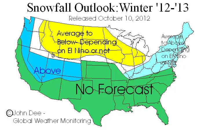
(Released: October 10, 2012)
It was my dearest hope that after last years round of seasonal forecasts (including my own) going up in a ball of flames not seen since the Hindenburg that most folks could finally come to the realization and the point that I make every year that: There is no way to reliably predict the weather on a seasonal scale, no matter what anyone says! My hopes began to get dashed when the questions of what I thought this winter was going to be like started coming in as early as August.
Those of you who have been following my site know that I am always been pretty low key and skeptical of any seasonal forecast- even my own. In fact I like to use the work "outlook" as I feel "forecast" should be reserved for something that has a little more proven science behind it.
For those of you that are relatively new to the site, you might want to click here and read my "Soap Box Speech on Seasonal Forecasting". For those of you that have read it before, no need to again- it is the same as in years past.
Before I go on, I must give credit to the only (as far as I know) meteorologist to accurately say last winter in the UP had a better than average chance of being milder than average. Karl Bohnak at Marquette's TV6 put in his Daily Weather Blog back in December that there was a strong correlation (something like 80% of the past years with similar setups) between mild Novembers in the UP and the rest of the winter also being mild. So congrats to Karl for making that connection and being the only forecaster that I know of that was able to give an accurate insight as to what last Dec-Feb would bring in the way of temperatures!
So, since there is still pressure for me to produce a winter forecast, I will once again put my thoughts on record, but do so in protest!!! J
If I were skilled enough technically to have some background music start up as you start to read this outlook, you would be hearing the beginning to the theme from the movie "Rocky". An announcer would then come into the middle of the boxing ring, a PA mic would drop from the upper reaches of the arena and he would say: "Ladies and Gentleman…" welcome to the winter of 2012/2013… We have a match up of historical proportions shaping up. In this corner…the heavyweight champion of the world and arch rival El Nino, with a record of 54 wins and 2 losses. In this corner the challenger, Even-Things Out, with a record of 23 wins and 12 losses….
Just what the heck to I mean by all of this silliness? Well, there is an El Nino brewing in the central Pacific. At the moment, conditions are still considered neutral, but are just a pigs hair away from being classified as a weak El Nino. As most know, El Nino is not the friend of snowlovers across much of the US- especially the north central US, where El Nino increases the chance of a mild winter. I can add this, while most forecasts call for the El Nino to develop within the next month or so and reach a peak in the Dec-March period, the forecast are not the most accurate and there are some hints that perhaps what is currently going on in the central Pacific could just be a head-fake. Meaning most of the sea surface temps in the area of the Pacific where El Nino occurs have either reached a plateau or are even cooling back down. Things regarding the status of El Nino really need to be measured on the time scale of 2-3 months, rather than daily, weekly or even monthly, so the verdict is still out on what exactly will happen with things in the central Pacific, but at this point it does not look like any El Nino that would develop would be a strong one by the time this winter unfolds and there are some ideas that the warming may have already peaked and some cooling will take place during the winter months.
The other tool that I like to use when trying to put together thoughts on a seasonal outlook is to look at previous weather trends for things like the past few months the past year and previous winters. I have found that over the long haul, mother nature likes to even out the score, meaning after a string of mild winters, there is an enhanced chance that the next winter will be cold and/or snowy. This does not always work (like most methods), but is one I tend to favor over other methods available. In any case, there is no question how mild last winter was across just about all the Midwest. Some areas ended up with close to average snowfall for the season, but frequent thaws ate away those snows and produced a winter that was lacking in consistent, good snow conditions and was plagued with above average temps and thaws. When you start to look back over the past 6 months, it includes one of the hotter summer periods to occur in the Midwest in many years. So those two factors would lead to an idea that a switch to colder than average temps is in the offing and ups the ante for this winter to be colder and perhaps snowier than average for much of the Midwest. However, if you go back and look at the past 3-5 winters, there was a string of winters that produced above average snowfall across areas like northeast IA, the southern 2/3rds of WI, northern IL and portions of MN and lower MI. The UP has not seen what would be considered a "hard winter" in many years. So the bottom line is, there are no strong signals when using this method, but I believe there is a slightly greater than average chance for this winter to be colder than average in much of the Midwest.
So combining the ideas from El Nino and from what I call "evening the score", I come to the cop-out solution that there are close to equal chances for above average, average and below average temps and snowfall for most of the Midwest. I am sure that there are countless eyes rolling right now and folks are saying to themselves; "I read through all of that garbage only to be told that there are equal chance for anything to happen!" Yes, that is what just happened, but anyone that knows me knows that I could care less about being glamorous in my forecasting. I call it like I see it and sometimes that means a pretty dull or undecided forecast. There are some minor enhancements that can be made to the general idea and I will discuss them below in the regional outlooks.
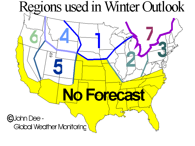
REGION 1– The Northwest Midwest: This is one of the areas that can be most negatively impacted by an El Nino with an increased chance for above average temps and thus less than average snowfall or days with suitable snow for snow-play. However, if the El Nino does not end up forming, or flames out as we head into winter, then this region could end up with an average winter when it comes to temps and snowfall. The further east you go in this region, the less correlation to the warmer than average El Nino winter there is.
As far as the all important UP-northern WI forecast goes, I think these are two areas that stand the best chance to see an average winter. I would be surprised if records were broken to either the harsh or mild case, but cannot rule those ideas out completely either. I also feel that there is a strong chance that the trend of three early ends to the season will come to an end with this winter. Sure snows will start to melt once March arrives, but the complete and total meltdown for many of these areas in early March is not very likely in my opinion.
REGION 2 – The Southeast Midwest: Overall, I think these areas are in for an average to slightly warmer than average, with the best chances for above average temps to occur the further north and west you go. Areas of the southern Midwest could actually see above average precip occur and this could lead to more than average snows, but one should not take this to mean it will be a harsh winter, just one that produces a storm or two that produces a healthy (4-8"+) snow that ends up melting within a week or so of falling- as it pretty typical for the far southern Midwest in an average winter.
REGION 3 – The Northeast US: I think that the presence or absence of an El Nino will play a role in the type of winter that this region sees. Like most of the snowbelts of the northern US, I think that the overall idea of equal chances for above average, average and below average temps and snowfall exists. However, in the presence of an El Nino, the scale gets tipped in the direction that above average snowfall and below average temps will occur. This is not a super strong correlation and with ideas being El Nino will be weak at best this winter, I would not be overly optimistic for a harsh winter, but to anticipate an average winter would not be a foolish way of thinking.
REGION 4 – The Northern Rockies: After a rather lack-luster winter with snows running below average for much of the northern Rockies, I think that much will hinge on what El Nino does. If an El Nino forms, then there is an enhanced chance that the winter will produce below average snowfall, with temps running close to average overall.
REGION 5 – The Central Rockies: As with the northern Rockies, much hinges on the presence or absence of an El Nino. However, the resultant snowfall for the upcoming winter is the opposite than in the north. If an El Nino does end up forming, then most of this region stands a better than average chance for above average snowfall to occur, with average temps. Thus, keep an eye on El Nino and if it forms, the theme in the Rockies will be: "Go South Young Man".
REGION 6 – The Pacific NW and Sierra Range: This region has one of the strongest correlation's to El Nino. Terms like the "Pineapple Express" pop up in El Nino winters to describe the fire hose stream of tropical moisture that an El Nino pattern can bring to areas of the west coast of the US. For coastal and low elevations this means rain, but for the higher elevations of the mountains inland, it means snows and in some cases, huge storms. The correlation is strongest for the region around Tahoe, but meaningful correlation's exist as far north as the Cascades of western WA and OR as well as the mountains of NV. Areas further east in OR and WA actually have an increased chance for below average snowfall in an El Nino winter.
REGION 7 – Eastern Canada: Oh Canada! The story for most of Ontario, Quebec and the Maritime Provinces is pretty similar to the Northeast US. Meaning that I believe there are equal chances of above, below or average winter snowfall and temps, but the presence of an El Nino could lead to above average snowfall and below average temps- especially the further east you go in this region.
<TABLE border=0 cellSpacing=1 cellPadding=0><TBODY><TR><TD align=center>
 </TD></TR><TR><TD align=center>
 </TD></TR></TBODY></TABLE>
Here is another. Looks to be setting the stage.
Here is a link also. Not looking good!
http://theweathercentre.blogspot.com/2012/09/official-2012-2013-winter-forecast_8.html
Updated
Here you go. Not looking good my friends.
http://www.wowt.com/weather/weatherblog/headlines/Winter_Forecast_181264251.html?mobile=yes
http://www.wowt.com/weather/weatherblog/headlines/Winter_Forecast_181264251.html?mobile=yes
Snow is starting to add up out west. Lets keep doing the snow dance.
U
I think our snowdances suck
Found untouched snow all day and it deep in the trees.
Similar threads
- Replies
- 2
- Views
- 622
- Replies
- 2
- Views
- 1K
- Replies
- 0
- Views
- 755
- Replies
- 6
- Views
- 1K