Install the app
How to install the app on iOS
Follow along with the video below to see how to install our site as a web app on your home screen.
Note: This feature may not be available in some browsers.

Google Earth
- Thread starter Wheel House Motorsports
- Start date
You are using an out of date browser. It may not display this or other websites correctly.
You should upgrade or use an alternative browser.
You should upgrade or use an alternative browser.
A
Have you noticed that the Ladybird, Russel Lake area in BC was taken in the winter.
You can see some of the nasty cornice work.
But you can't see the road in the meadows and such. But it is a totally different perspective compaired to the standard green trees and such.
Thunder
You can see some of the nasty cornice work.
But you can't see the road in the meadows and such. But it is a totally different perspective compaired to the standard green trees and such.
Thunder
We also use it alot, Download my waypoints onto a google map, see where you been and how far certain parks are. Works good
Try the flight simulator, Ctrl/Alt a
M
I have have overlayed some maps on Google earth of these riding area's in Revelstoke BC
Boulder
Frisby
Keystone
Have a look on the Boulder one you can see sleds trailers in the parking lot and the groomed trail going up then it turns to green!!
You can dim the map by the slide on the left hand side. You can also see the Boulder cabin (summer) just to the left of the cabin marked on the map. The map is fairly close but as you can see the trails are a little out.
Oh ya by the way I love Google earth!!
Last edited:
M
Just for kicks I looked at an area to see what Google Earth showed. The area that they showed is over 6 years old, and that was with the newest software they had. Looks like to me that they need to update some.
Just for kicks I looked at an area to see what Google Earth showed. The area that they showed is over 6 years old, and that was with the newest software they had. Looks like to me that they need to update some.
Yeah...I'm sure the rocks grew by now.

M
Yeah...I'm sure the rocks grew by now.
What I looked at was the town I live in.
And, YES rocks do grow, just ask some of the sledders out there!!!!!
M
Just for kicks I looked at an area to see what Google Earth showed. The area that they showed is over 6 years old, and that was with the newest software they had. Looks like to me that they need to update some.
it is a predictive update...if no one spends a lot of time looking at a certain area, they dont update it...
I purchased a map from them, for a hunting trip, when I got back looked at the map again, and low and behold they updated the image, and you could see my hunting camp in the map!!!!!
key thing though you have to enable the feature to let them know what locations you are looking at...
M
I use google earth a lot when I am trying to get into an area. My garmin rino and mapsource works in conjunction with G.E. and I can also see where I have been. you can pan around and check what is over the ridge...etc.
For the height accuracy, well, I don't think it is that far out , but I have looked at Monster, and it shows 890 feet MAX, but some claim 1500.
I would rather see what it looks like in the summer, then you can see where the nasty boulders are.
The maps from my home town are over 6 years old.
I went looking at my father's home stomping grounds, which is now Russia... I made a comment on some photos that were posted, and the guy who took them and posted them sent me an e-mail, saying that he is a professional photographer, and he sent me some pics of the landmarks,,, pretty cool, to show my father, since he wasn't there since WWII.
I have also posted some scenic views from my sledding experiences on panoramio
T
key thing though you have to enable the feature to let them know what locations you are looking at...
Yes, how do you enable this feature?? My home town & riding area must have been mapped with Sputnik. Can't see anything closer than 11 mile eye view.
M
Yes, how do you enable this feature?? My home town & riding area must have been mapped with Sputnik. Can't see anything closer than 11 mile eye view.
first things first, what version of google earth are you on? the newest version is 4.3 adn if you are not on that, you need to upgrade...
then one of the options is, enable google earth tracking...and if you enable that, it will send it out as a map location to update...
T
first things first, what version of google earth are you on? the newest version is 4.3 adn if you are not on that, you need to upgrade...
then one of the options is, enable google earth tracking...and if you enable that, it will send it out as a map location to update...
This is what my version is:
Google Earth
4.3.7204.0836 (beta)
I see no option for tracking. Maybe it's because of the beta version!
E
you can enable snotel overlays on GE, and all kinds of other cool stuff...
have it and link a path up to my Rhino, and can find ALL kinds of KILLER play areas....this was the first year, I charted courses and followed them via my Rhino, which was WAYYYYYYY cool!!!!
DANG! How?? You should consult for $$. I'd pay for that kind of knowledge.
M
Snotel overlays....linky clicky has destructions and everything
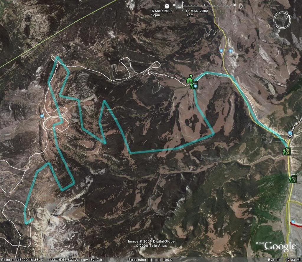
with Rino, get the Mapsource topo, and then you can enable path tracking on your unit, and then just click on upload...then click view, then view in google earth..and it will give you similar image to what I posted...
with Rino, get the Mapsource topo, and then you can enable path tracking on your unit, and then just click on upload...then click view, then view in google earth..and it will give you similar image to what I posted...
I got my GPS talkin to my computer a while ago, it leaves digital breadcrumbs as I go and those can be dumped into a computer and plotted over google maps... www.gpsvisualizer.com
So I'm just now getting into using Google Earth to see the areas we ride. In digging around old SW posts on this topic, I'm trying to understand how this works.
After loading GE 5.0 on my PC, I see the app will download waypoints directly off my GPS but for some reason it's not grabbing the recorded track log. This post mentions "gpsvisualizer" - is this how you're supposed to get the tracks off the GPS and into GE?? What might I be doing wrong in order to get GE to do it directly?
E
GPS Visualizer is a web site you can upload a GPX to that will plot the waypoints/tracks on google maps. You can then easily share that track with other people by emailing them a link.
Google Earth adds a lot more functionality, but requires the download of Google Earth.
First step is to be able to get the data off the GPS into a useable file (Either KML or GPX, i prefer GPX. Less data, but it's a lot more manageable).
Then drop that KML/GPX file into google earth.
Google Earth adds a lot more functionality, but requires the download of Google Earth.
First step is to be able to get the data off the GPS into a useable file (Either KML or GPX, i prefer GPX. Less data, but it's a lot more manageable).
Then drop that KML/GPX file into google earth.
J
Google Pic's

Google & Rino Track

Number "Four"

Peace Out
Johnny
.
Google & Rino Track
Number "Four"
Peace Out
Johnny
.
Last edited:
I use the SPOT locator when I ride, then when I get home I download the .gpx file into Google Earth and view all the places I rode in GE. VERY NICE!
Similar threads
K
- Replies
- 10
- Views
- 2K
A
B
- Replies
- 7
- Views
- 782
P
- Replies
- 38
- Views
- 3K
- Replies
- 39
- Views
- 4K