
http://powderchasers.com/forecasts/updated-snow-totals-new-england-west-1-2-feet-east-2-5-feet-west
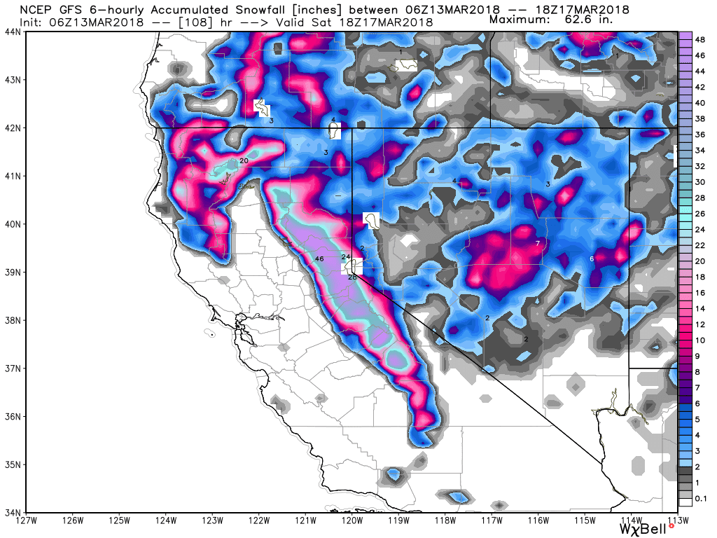
In the West, all action turns to California through Saturday. Peak snowfall will happen Tuesday night into Wednesday (Warm followed by cold), and again Thursday night and Friday. Expect 9-14 inches by Wednesday morning and another 1-2 feet for Friday. The southern Sierra seems favored with Mammoth most likely scoring 4-6 feet at the summit by Friday afternoon. There is a distinct break on Thursday so if anyone is lucky, summits might pop (Miracle for Mammoth). Additional light or moderate snow will be likely Friday night into Saturday (5-8).
Below: Total snowfall in the Sierra through Saturday morning.
Light to moderate snow is likely in many areas of the Rockies by Wednesday. Its going to be a quick 3-5 inches at upper elevations favoring central Idaho, Western Montana and perhaps the Wasatch with any luck. The Euro shows a chance of 5-10 inches for the highest peaks of the Wasatch (Northern areas are favored with SW flow as well as BCC) by Thursday morning. The GFS shows less.
In the Cascades, chase if your there for Wednesday with 4-7 inches likely above 4,000 feet (Baker may see higher amounts).
In Colorado, I am bullish for moderate snowfall for the highest peaks of the San Juan Mountains Thursday. 5-11 inches are likely above 9500 feet near Wolf Creek by late Thursday or early Friday (Most snow falls late Wednesday night into Thursday afternoon). Winds shift from the SW to the west Thursday afternoon shifting snow to most of the central and northern mountains. Crested Butte may fare best with 4-7 inches by late Thursday night followed by the I-70 corridor late Thursday and Friday (3-6 inches). Its possible that Friday morning sees some sneak up powder days for the I-70 corridor.
Below: Total snowfall in Colorado through Friday morning

Drive safely if you are chasing! In California you must carry chains on any non 4X4 (You will need to use them) and in some cases wacky rules require them on AWD. Look for possible road closures especially Friday morning on I-80 so plan back routes . The Weekend will deliver openings both Saturday and Sunday especially upper mountain.

In the West, all action turns to California through Saturday. Peak snowfall will happen Tuesday night into Wednesday (Warm followed by cold), and again Thursday night and Friday. Expect 9-14 inches by Wednesday morning and another 1-2 feet for Friday. The southern Sierra seems favored with Mammoth most likely scoring 4-6 feet at the summit by Friday afternoon. There is a distinct break on Thursday so if anyone is lucky, summits might pop (Miracle for Mammoth). Additional light or moderate snow will be likely Friday night into Saturday (5-8).
Below: Total snowfall in the Sierra through Saturday morning.
Light to moderate snow is likely in many areas of the Rockies by Wednesday. Its going to be a quick 3-5 inches at upper elevations favoring central Idaho, Western Montana and perhaps the Wasatch with any luck. The Euro shows a chance of 5-10 inches for the highest peaks of the Wasatch (Northern areas are favored with SW flow as well as BCC) by Thursday morning. The GFS shows less.
In the Cascades, chase if your there for Wednesday with 4-7 inches likely above 4,000 feet (Baker may see higher amounts).
In Colorado, I am bullish for moderate snowfall for the highest peaks of the San Juan Mountains Thursday. 5-11 inches are likely above 9500 feet near Wolf Creek by late Thursday or early Friday (Most snow falls late Wednesday night into Thursday afternoon). Winds shift from the SW to the west Thursday afternoon shifting snow to most of the central and northern mountains. Crested Butte may fare best with 4-7 inches by late Thursday night followed by the I-70 corridor late Thursday and Friday (3-6 inches). Its possible that Friday morning sees some sneak up powder days for the I-70 corridor.
Below: Total snowfall in Colorado through Friday morning
Drive safely if you are chasing! In California you must carry chains on any non 4X4 (You will need to use them) and in some cases wacky rules require them on AWD. Look for possible road closures especially Friday morning on I-80 so plan back routes . The Weekend will deliver openings both Saturday and Sunday especially upper mountain.


